開啟輔助訪問
 找回密碼
 立即加入

13L.Melissa NHC:160KT 年度風王 先後登陸牙買加 古巴 重創牙買加

簽到天數: 1866 天

[LV.Master]伴壇終老

typhoonman|2025-11-7 16:20 | 顯示全部樓層
本帖最後由 typhoonman 於 2025-11-7 16:23 編輯
蜜露 發表於 2025-11-2 20:21
北部 蒙特哥貝 出海的風雨.... 牙買加沒有高山

1個是Youtube 另外2個是Bilibili

梅莉莎最後一次飛機時側南象限測到219kts風速

Coming back on Hurricane Melissa and it seems a possible dropsonde on the southern quadrant of the eyewall of 219-knot (252 mph) gust was measured. The gust occurred around 250m from the surface as well. If this is very much true, it is plausible to say Melissa could’ve been the strongest measured hurricane in terms of wind speeds. Almost certain the NHC will analyze this in the Post Tropical Cyclone Report.
用GOOGLE翻譯原文
回到颶風梅莉莎的話題,似乎在其眼牆南象限的投落式探空儀上測得了219節(252英里/小時)的陣風。該陣風出現在距離地面約250公尺處。如果情況屬實,那麼梅莉莎很可能成為有史以來風速最強的颶風。幾乎可以肯定,美國國家颶風中心(NHC)將在熱帶氣旋後報告中進行分析。


摘錄於X Jordan S


回復

使用道具 舉報

簽到天數: 1866 天

[LV.Master]伴壇終老

typhoonman|2025-11-7 16:27 | 顯示全部樓層
本帖最後由 typhoonman 於 2025-11-7 16:29 編輯
typhoonman 發表於 2025-11-7 16:20
梅莉莎最後一次飛機時側南象限測到219kts風速

Coming back on Hurricane Melissa and it seems a possibl ...

梅莉莎也出現融合式置換眼牆
英文原文:
Almost all Major Hurricanes undergo an eyewall replacement cycle.

Melissa never did.

She sustained CATEGORY 5 status for 35 consecutive hours, the 8TH longest total duration of Cat 5 winds ever documented in an Atlantic Hurricane, and the longest since Hurricane Irma in 2017. Instead of initiating replacement cycles, Melissa underwent eyewall mergers, which caused only short-lived pauses in her intensification and allowed her to incrementally climb to an extreme strength as she slowly writhed towards Jamaica. It is exceptionally rare to see a high-level Hurricane eye remain so perfectly circular and clear for so many days on end.
用GOOGLE翻譯後全文
幾乎所有大型颶風都會經歷眼牆置換週期。

梅麗莎從來沒有這樣做過。

她連續35小時保持五級颶風強度,這是大西洋颶風有史以來持續時間第八長的五級颶風,也是自2017年颶風艾爾瑪以來持續時間最長的五級颶風。梅麗莎颶風沒有經歷眼牆置換週期,而是發生了眼牆合併,這只導致其強度增強過程短暫中斷,並使其在緩慢向牙買加移動的過程中逐漸增強至極高強度。如此高空的颶風眼能夠連續多日保持如此完美的圓形和清晰可見,實屬罕見。

摘錄於X Backpirch Weather


點評

長時間的 T 7.5 以上 也只有 1985 Hina 能比的上而已  發表於 2025-11-7 22:40
回復

使用道具 舉報

簽到天數: 582 天

[LV.9]以壇為家II

蜜露|2025-11-20 17:56 | 顯示全部樓層
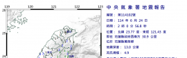
本帖最後由 蜜露 於 2025-11-20 17:59 編輯


投落送最大陣風紀錄  2025 梅麗莎颶風 觀測史上最高   

NSF NCAR staff are continuously advancing  dropsonde technology, including the development of tools to analyze the data from dropsondes. In order to verify the wind reading from Hurricane Melissa, Vömel and other NSF NCAR researchers scrutinized the data and ran it through a post-processing software called Aspen that performs quality control. They checked that the reported numbers tracked with the laws of physics and typical behavior of hurricanes and that there were no gaps in reported measurements. When no anomalies were found, they confirmed that the measurement could be trusted. Hurricane Melissa’s 252 mph wind gust surpassed the previous record from Typhoon Megi over the Western Pacific in 2010, where a dropsonde measured wind gusts of 248 mph.


NSF NCAR 工作人員持續推動降落探空儀技術,包括開發分析投落探空儀數據的工具。為了驗證颶風梅麗莎的風速讀數,Vömel 與其他 NSF NCAR 研究人員仔細分析數據,並透過名為 Aspen 的後處理軟體進行品質控管。他們檢查報告的數據是否符合物理定律及颶風典型行為,且報告的測量數據無漏洞。當未發現異常時,他們確認該測量結果可信。颶風梅麗莎的252英里每小時陣風超越了2010年颱風梅吉在西太平洋的紀錄,當時以降落探空儀測量的陣風達248英里每小時。


2025 梅麗莎 Melissa   219Kts (252mph)
2010 梅姬 Megi    216Kts (248mph)


回復

使用道具 舉報

簽到天數: 582 天

[LV.9]以壇為家II

蜜露|2025-12-17 01:16 | 顯示全部樓層


iCyclone 終於更新了 Melissa


回復

使用道具 舉報

12345
快速回覆
您需要登錄後才可以回帖 登錄 | 立即加入

本版積分規則

本平台僅供學術討論之用,預報應以氣象局為準

威普網站虛擬主機贊助公司

臺灣第一個天氣類型社群平台 即時天氣資訊、精準颱風動態

線上客服
FB傳送訊息
廣告行銷
精準行銷 物超所值
官方粉專
發佈 快速回復 返回頂部 返回列表