開啟輔助訪問
 找回密碼
 立即加入

15S.Marcus 風眼清空達巔峰 澳洲海域12年以來最強TC

簽到天數: 3291 天

[LV.Master]伴壇終老

t02436|2018-3-16 12:14 | 顯示全部樓層
00Z命名Marcus
IDD20020
TROPICAL CYCLONE TECHNICAL BULLETIN: AUSTRALIA - NORTHERN REGION
Issued by DARWIN TROPICAL CYCLONE WARNING CENTRE
at: 0202 UTC 16/03/2018
Name: Tropical Cyclone Marcus
Identifier: 20U
Data At: 0000 UTC
Latitude: 10.3S
Longitude: 132.6E
Location Accuracy: within 30 nm [55 km]
Movement Towards: southeast [135 deg]
Speed of Movement: 7 knots [13 km/h]
Maximum 10-Minute Wind: 35 knots [65 km/h]
Maximum 3-Second Wind Gust: 50 knots [95 km/h]
Central Pressure: 998 hPa
Radius of 34-knot winds NE quadrant: 50 nm [95 km]
Radius of 34-knot winds SE quadrant: 40 nm [75 km]
Radius of 34-knot winds SW quadrant: 40 nm [75 km]
Radius of 34-knot winds NW quadrant: 50 nm [95 km]
Radius of 48-knot winds NE quadrant:   
Radius of 48-knot winds SE quadrant:   
Radius of 48-knot winds SW quadrant:   
Radius of 48-knot winds NW quadrant:   
Radius of 64-knot winds:   
Radius of Maximum Winds: 15 nm [30 km]
Dvorak Intensity Code: T3.0/3.0/D1.5/24HRS D0.5/06HRS
Pressure of outermost isobar: 1006 hPa
Radius of outermost closed isobar: 150 nm [280 km]
FORECAST DATA
Date/Time    : Location    : Loc. Accuracy: Max Wind   : Central Pressure
[UTC]        : degrees     :      nm  [km]: knots[km/h]: hPa
+06:  16/0600: 10.7S 132.7E:     050 [095]:  040  [075]:  998
+12:  16/1200: 11.1S 132.6E:     065 [120]:  040  [075]:  998
+18:  16/1800: 11.5S 132.3E:     075 [145]:  040  [075]:  998
+24:  17/0000: 12.0S 131.7E:     090 [165]:  035  [065]:  998
+36:  17/1200: 12.9S 130.3E:     110 [200]:  035  [065]:  996
+48:  18/0000: 13.4S 128.6E:     130 [235]:  040  [075]:  994
+60:  18/1200: 14.0S 126.3E:     150 [275]:  050  [095]:  992
+72:  19/0000: 14.5S 123.8E:     165 [310]:  055  [100]:  988
+96:  20/0000: 14.6S 118.3E:     210 [390]:  075  [140]:  973
+120: 21/0000: 14.6S 111.8E:     300 [555]:  090  [165]:  960
REMARKS:
Latest position based on Warruwi radar with good confidence.

A partial ASCAT pass at 15/13Z ind gales in the northwest quadrant and recent
microwave imagery has shown convective banding wrapping strongly around the west
to northwest to northeast quadrants.

Recent observations: 36kn at McCluer Island at 16/0130Z.

Dvorak 16/00Z: Curved band of 0.5 gives DT 2.5. MET and PAT are 3.0 based on D+
trend. FT is based on MET.

20U was upgraded to Tropical Cyclone Marcus based on improved structure in
microwave, radar and satellite and supported by the Dvorak subjective
assessment.

At 15/18Z CIMSS winds shear indicated moderate easterly shear of 20 to 30 knots
but recent satellite imagery suggests this is easing.

Initial track movement is to the SSE under the influence of a westerly wind
surge to the north of the system. The tropical low is forecast to turn south and
move close to the north coast of the Northern Territory today due to a mid level
ridge to the east. The system is expected to curve to the southwest and towards
the Timor Sea in 24 to 48 hours as a mid latitude trough moves east across the
Great Australian Bight and pushes the mid level ridge over southern Australia
further north, creating an easterly steering. Development is expected to be at a
standard rate, aided by a  Rossby wave arriving over western Arafura Sea and
Timor Sea today, decreasing environmental shear closer to the NT coast and
continued favorouble low level surges.

Development may be hindered by land influences and ingestion of dry air on the
outer western flank. Once the tropical low moves into the Timor Sea during the
weekend, development is likely to continue at a standard after briefly
entangling with the north Kimberley coast. Steering will remain easterly long
term due to a strong mid level ridge to the south, taking the system into the
Indian Ocean.

Copyright Commonwealth of Australia
==
The next bulletin for this system will be issued by: 16/0800 UTC by Darwin TCWC.

IDD65001.png

sh152018.20180316030627.gif

20180316.0340.himawari-8.ircolor.15S.FIFTEEN.40kts.1001mb.10.6S.132.6E.100pc.jpg
回復

使用道具 舉報

簽到天數: 601 天

[LV.9]以壇為家II

霧峰追風者|2018-3-17 06:46 | 顯示全部樓層
本帖最後由 霧峰追風者 於 2018-3-17 06:47 編輯

BoM 強度升二級熱帶氣旋,侵襲澳洲北部陸地,穩定西移,後期看好強度發展。
IDD65001 (2).png

JTWC 強度上望四級颶風( 120kts )。 sh1518 (1).gif 20180316.1902.noaa19.89rgb.15S.MARCUS.40kts.993mb.11.7S.131.6E.100pc.jpg rbtop-animated (1).gif


回復

使用道具 舉報

簽到天數: 601 天

[LV.9]以壇為家II

霧峰追風者|2018-3-17 10:11 | 顯示全部樓層
BoM 最新一報判定登陸。
IDD20020
TROPICAL CYCLONE TECHNICAL BULLETIN: AUSTRALIA - NORTHERN REGION
Issued by DARWIN TROPICAL CYCLONE WARNING CENTRE
at: 0157 UTC 17/03/2018
Name: Tropical Cyclone Marcus
Identifier: 20U
Data At: 0100 UTC
Latitude: 12.4S
Longitude: 130.9E
Location Accuracy: within 5 nm [9 km]
Movement Towards: southwest [221 deg]
Speed of Movement: 11 knots [20 km/h]
Maximum 10-Minute Wind: 50 knots [95 km/h]
Maximum 3-Second Wind Gust: 70 knots [130 km/h]
Central Pressure: 982 hPa
Radius of 34-knot winds NE quadrant: 60 nm [110 km]
Radius of 34-knot winds SE quadrant: 30 nm [55 km]
Radius of 34-knot winds SW quadrant: 30 nm [55 km]
Radius of 34-knot winds NW quadrant: 50 nm [95 km]
Radius of 48-knot winds NE quadrant: 10 nm [20 km]
Radius of 48-knot winds SE quadrant: 10 nm [20 km]
Radius of 48-knot winds SW quadrant: 10 nm [20 km]
Radius of 48-knot winds NW quadrant: 10 nm [20 km]
Radius of 64-knot winds:   
Radius of Maximum Winds: 10 nm [20 km]
Dvorak Intensity Code: T3.5/3.5/D0.5/24HRS STT:D0.5/03HRS
Pressure of outermost isobar: 1006 hPa
Radius of outermost closed isobar: 90 nm [165 km]
FORECAST DATA
Date/Time    : Location    : Loc. Accuracy: Max Wind   : Central Pressure
[UTC]        : degrees     :      nm  [km]: knots[km/h]: hPa
+06:  17/0700: 12.9S 130.4E:     020 [040]:  045  [085]:  989
+12:  17/1300: 13.3S 129.7E:     035 [065]:  045  [085]:  991
+18:  17/1900: 13.6S 129.0E:     045 [085]:  050  [095]:  989
+24:  18/0100: 13.9S 128.3E:     060 [110]:  055  [100]:  986
+36:  18/1300: 14.4S 126.5E:     080 [145]:  055  [100]:  985
+48:  19/0100: 14.7S 124.3E:     100 [180]:  060  [110]:  982
+60:  19/1300: 15.0S 122.1E:     120 [220]:  070  [130]:  971
+72:  20/0100: 14.8S 119.5E:     135 [255]:  085  [155]:  963
+96:  21/0100: 14.5S 113.4E:     180 [335]:  100  [185]:  948
+120: 22/0100: 15.3S 108.1E:     270 [500]:  100  [185]:  947
REMARKS:
During the last 6 hours, satellite imagery has shown strong convection
persisting over the low level circulation centre and tight curved banding.
Berrimah radar has shown a rapidly consolidating low level circulation with
tight spiral bands and the formation of a partial eye way on the northern
semicircle. Microwave imagery has shown a developing eye at 85 GHz from an
AMSU-B pass at 16/1902Z to a TC_SSMIS pass image at 16/2051Z.

The intensity of TC Marcus was upgraded to Category 2 at 16/21Z based on all of
these factors, despite Dvorak estimates suggesting lower intensity.

Dvorak at 17/00Z: DT 3.0 based on 0.7 wrap curved band. MET and PAT are 3.5
based on D trend over 24 hours. FT based on MET.

Recent observations:
- Darwin Airport: 47kn at 0133Z. Gusts to 65kn [120 km/h].
- Darwin Harbour NTC: Gust to 65kn. Minimum pressure 981.6 hPa at 0127Z.
Point Stuart reported gales to 35kn and gusts to 50kn briefly from 16/21Z to
16/22Z.

The upper level ridge lies just to the south of TC Marcus. Water vapour imagery
shows good outflow to the NW sector, weaker outflow to the S sector but
constrained outflow to the E. CIMSS vertical wind shear at 17/00Z was easterly
at 19 knots.

The latest position is made with good confidence based on Berrimah radar and is
located jnear Darwin Harbour.

The system is expected to adopt a SW track past Darwin and towards the Timor Sea
over the next 12 to 24
hours as a mid latitude trough moves east across the Great Australian Bight and
pushes the mid level ridge over southern Australia further north, creating a
stronger easterly steering.

Tropical Cyclone Marcus may weaken briefly to below category 2 as it interacts
with the Darwin coastline. Once the tropical low moves into the Timor Sea during
tonight, development is likely to continue at a standard rate or faster,
reaching category 2 prior to corssing the NE Kimbery coast on Sunday. Steering
will remain easterly long term due to a strong mid level ridge to the south,
taking the system into the Indian Ocean where it will continue to intensify
strongly  over open waters to a Severe Tropical Cyclone.


Copyright Commonwealth of Australia
==
The next bulletin for this system will be issued by: 17/0800 UTC by Darwin TCWC.
IDD65001 (3).png rbtop-animated (2).gif

回復

使用道具 舉報

簽到天數: 588 天

[LV.9]以壇為家II

Meow|2018-3-17 15:42 | 顯示全部樓層
雖然略微減弱至一級,但本報大幅調高後期預期,已經上看125節,而責任區長達12年沒超過120節的系統。
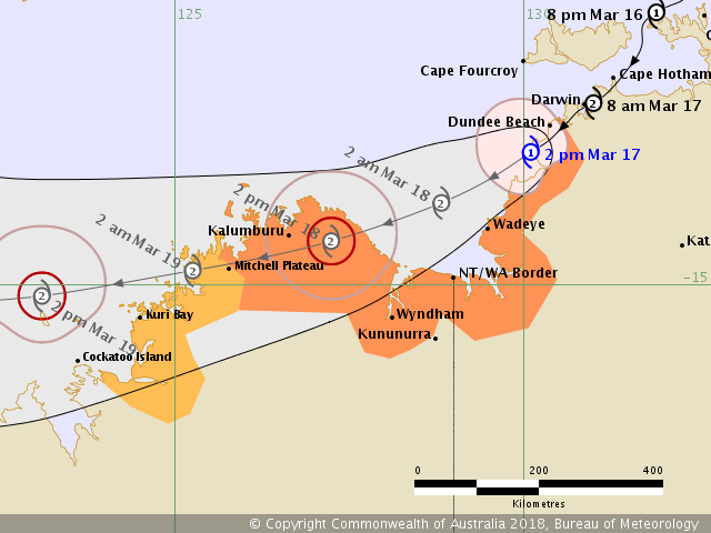
IDWP0005.png
  1. IDD20020
  2. TROPICAL CYCLONE TECHNICAL BULLETIN: AUSTRALIA - NORTHERN REGION
  3. Issued by DARWIN TROPICAL CYCLONE WARNING CENTRE
  4. at: 0711 UTC 17/03/2018
  5. Name: Tropical Cyclone Marcus
  6. Identifier: 20U
  7. Data At: 0600 UTC
  8. Latitude: 13.1S
  9. Longitude: 130.1E
  10. Location Accuracy: within 15 nm [30 km]
  11. Movement Towards: southwest [231 deg]
  12. Speed of Movement: 11 knots [21 km/h]
  13. Maximum 10-Minute Wind: 45 knots [85 km/h]
  14. Maximum 3-Second Wind Gust: 65 knots [120 km/h]
  15. Central Pressure: 992 hPa
  16. Radius of 34-knot winds NE quadrant: 35 nm [65 km]
  17. Radius of 34-knot winds SE quadrant: 20 nm [35 km]
  18. Radius of 34-knot winds SW quadrant: 40 nm [75 km]
  19. Radius of 34-knot winds NW quadrant: 50 nm [95 km]
  20. Radius of 48-knot winds NE quadrant:   
  21. Radius of 48-knot winds SE quadrant:   
  22. Radius of 48-knot winds SW quadrant:   
  23. Radius of 48-knot winds NW quadrant:   
  24. Radius of 64-knot winds:   
  25. Radius of Maximum Winds: 10 nm [20 km]
  26. Dvorak Intensity Code: T3.0/3.5/S0.0/24HRS STT:W0.5/03HRS
  27. Pressure of outermost isobar: 1004 hPa
  28. Radius of outermost closed isobar: 90 nm [165 km]
  29. FORECAST DATA
  30. Date/Time    : Location    : Loc. Accuracy: Max Wind   : Central Pressure
  31. [UTC]        : degrees     :      nm  [km]: knots[km/h]: hPa
  32. +06:  17/1200: 13.5S 129.5E:     020 [040]:  045  [085]:  990
  33. +12:  17/1800: 13.8S 128.8E:     035 [065]:  050  [095]:  989
  34. +18:  18/0000: 14.1S 128.1E:     045 [085]:  055  [100]:  987
  35. +24:  18/0600: 14.4S 127.2E:     060 [110]:  060  [110]:  985
  36. +36:  18/1800: 14.8S 125.3E:     080 [145]:  050  [095]:  984
  37. +48:  19/0600: 15.2S 123.1E:     100 [180]:  060  [110]:  978
  38. +60:  19/1800: 15.2S 120.7E:     120 [220]:  080  [150]:  968
  39. +72:  20/0600: 15.0S 118.0E:     135 [255]:  090  [165]:  960
  40. +96:  21/0600: 14.9S 111.9E:     180 [335]:  110  [205]:  948
  41. +120: 22/0600: 15.9S 106.9E:     270 [500]:  125  [230]:  946
  42. REMARKS:
  43. Latest radar imagery shows TC Marcus on the coast SW of Darwin. Position is
  44. becoming increasingly difficult as TC Marcus moves away from Berrimah radar.

  45. During the last 6 hours, the destructive core of TC Marcus passed directly over
  46. Darwin and has now spent 6-8 hours over land just inland of the coast. Marcus
  47. has been dowgraded from category 2 to category 1 based on a weakening of the
  48. cyclone's core, as indicated on radar, and due to surrounding coastal
  49. observations. A SSMIS microwave image at 0602Z confirms the weakened structure,
  50. when the strongest convection over water NW of the LLCC.

  51. Dvorak at 17/06Z: DT 3.0 based on 0.7 wrap curved band. MET is 3.0 and PAT is
  52. 3.5. FT based on DT of of 3.0, with CI held higher at 3.5. However, as the LLCC
  53. is over land, maximum winds are set at 45 knots.

  54. Recent observations:
  55. - Darwin Airport: 47kn at 17/0133Z. Gusts to 68kn [126 km/h] at 17/0130Z.
  56. - Darwin Harbour NTC: Gust to 70kn [130 km/h] at 17/0200Z. Minimum pressure
  57. 981.6 hPa at 0127Z.
  58. - Point Stuart reported gales to 35kn and gusts to 50kn briefly from 16/21Z to
  59. 16/22Z.

  60. The upper level ridge lies just to the south of TC Marcus. Water vapour imagery
  61. shows good outflow to the NW sector, weaker outflow to the S sector but
  62. constrained outflow to the E. CIMSS vertical wind shear at 17/00Z was easterly
  63. at 19 knots.

  64. The system is expected to maintain a SW track towards the Timor Sea as a mid
  65. latitude trough moves east across the Great Australian Bight and pushes the mid
  66. level ridge over southern Australia further north, creating a stronger easterly
  67. steering.

  68. Once the tropical low moves into the Timor Sea during tonight, development is
  69. likely to continue at a standard rate or faster, reaching category 2 prior to
  70. corssing the NE Kimbery coast on Sunday, although there is a small possibility
  71. of reaching category 3. Steering will remain easterly long term due to a strong
  72. mid level ridge to the south, taking the system into the Indian Ocean where it
  73. will continue to intensify strongly  over open waters to a Severe Tropical
  74. Cyclone.


  75. Copyright Commonwealth of Australia
  76. ==
  77. The next bulletin for this system will be issued by: 17/1400 UTC by Perth TCWC.
複製代碼
回復

使用道具 舉報

簽到天數: 601 天

[LV.9]以壇為家II

霧峰追風者|2018-3-18 04:57 | 顯示全部樓層
在帝文海強度從回二級熱帶氣旋,將二次登陸澳洲北部,預測48H後強度升澳式C3,巔峰上看澳式C5( 125KT )。
IDW27600
TROPICAL CYCLONE TECHNICAL BULLETIN: AUSTRALIA - WESTERN REGION
Issued by PERTH TROPICAL CYCLONE WARNING CENTRE
at: 1919 UTC 17/03/2018
Name: Tropical Cyclone Marcus
Identifier: 20U
Data At: 1800 UTC
Latitude: 13.8S
Longitude: 128.7E
Location Accuracy: within 15 nm [30 km]
Movement Towards: west southwest [243 deg]
Speed of Movement: 8 knots [14 km/h]
Maximum 10-Minute Wind: 55 knots [100 km/h]
Maximum 3-Second Wind Gust: 75 knots [140 km/h]
Central Pressure: 984 hPa
Radius of 34-knot winds NE quadrant: 50 nm [95 km]
Radius of 34-knot winds SE quadrant: 40 nm [75 km]
Radius of 34-knot winds SW quadrant: 50 nm [95 km]
Radius of 34-knot winds NW quadrant: 50 nm [95 km]
Radius of 48-knot winds NE quadrant: 20 nm [35 km]
Radius of 48-knot winds SE quadrant: 20 nm [35 km]
Radius of 48-knot winds SW quadrant: 20 nm [35 km]
Radius of 48-knot winds NW quadrant: 20 nm [35 km]
Radius of 64-knot winds:   
Radius of Maximum Winds: 15 nm [30 km]
Dvorak Intensity Code: T3.5/3.5/D0.5/24HRS STT:D0.5/06HRS
Pressure of outermost isobar: 1004 hPa
Radius of outermost closed isobar: 80 nm [150 km]
FORECAST DATA
Date/Time    : Location    : Loc. Accuracy: Max Wind   : Central Pressure
[UTC]        : degrees     :      nm  [km]: knots[km/h]: hPa
+06:  18/0000: 14.1S 128.0E:     040 [080]:  060  [110]:  981
+12:  18/0600: 14.3S 127.0E:     055 [100]:  060  [110]:  981
+18:  18/1200: 14.5S 126.0E:     065 [125]:  050  [095]:  988
+24:  18/1800: 14.7S 124.9E:     080 [145]:  050  [095]:  988
+36:  19/0600: 15.1S 122.9E:     100 [180]:  065  [120]:  978
+48:  19/1800: 15.1S 120.6E:     120 [220]:  080  [150]:  966
+60:  20/0600: 14.7S 117.9E:     140 [255]:  090  [165]:  957
+72:  20/1800: 14.4S 115.0E:     155 [290]:  100  [185]:  948
+96:  21/1800: 15.0S 109.2E:     200 [370]:  120  [220]:  925
+120: 22/1800: 17.3S 105.7E:     290 [535]:  125  [230]:  917
REMARKS:
Latest radar imagery shows TC Marcus moving through the southern Timor Sea.
Confidence in the position is high, with a well-defined circulation evident on
the Wyndham radar.

Marcus crossed the coast north of Darwin on Saturday morning as a Category 2
system. It proceeded to weaken during Saturday as it moved over land, before
returning over water on Saturday evening. It has now intensified back into a
Category 2 system.

Recent satellite imagery has shown a curved band developing around the low level
centre, with a wrap of around 0.9. This yields a DT of 3.5. MET is 3.5 based on
a slight developing trend, with no adjustment made for Pattern. FT and CI set at
3.5. This is consistent with CIMSS and NESDIS ADT [3.6 and 3.4 respectively].
SATCON has the system at 60 knots [one minute mean]. The system's intensity is
currently set to 55 knots [ten minute mean].

The upper level ridge lies just to the south of TC Marcus. Development is being
assisted by strong upper divergence and good outflow, particularly on the
equatorward side of the system. CIMSS vertical wind shear has decreased to
easterly at around 15 knots, and system-relative shear would be less than 10
knots given the current motion.

The system is expected to maintain a W/SW track during Sunday as a mid latitude
trough moves east across the Great Australian Bight and pushes the mid level
ridge over southern Australia further north, creating stronger easterly
steering.

As the systems moves through the Timor Sea over the next 6-12 hours, development
is likely to continue at a standard rate or faster. It is possible that the
system could reach Category 3 intensity before crossing the coast later on
Sunday morning.

Steering will remain easterly long term due to a strong mid level ridge to the
south, taking the system off the northwest Kimberley coast on Monday morning and
then into the Indian Ocean. Once over water again, the system is likely to
continue intensifying, and may reach Category 5 intensity when it is well north
of the Australian mainland.

Copyright Commonwealth of Australia
==
The next bulletin for this system will be issued by: 18/0130 UTC by Perth TCWC.
IDW60280.png 20180317.1851.noaa19.89rgb.15S.MARCUS.50kts.985mb.13.9S.128.6E.095pc.jpg rbtop-animated.gif

回復

使用道具 舉報

簽到天數: 601 天

[LV.9]以壇為家II

霧峰追風者|2018-3-18 11:18 | 顯示全部樓層
再次登陸澳洲北部。
IDW60280 (1).png 20180318.0037.metopb.89rgb.15S.MARCUS.55kts.994mb.14.2S.127.8E.095pc.jpg rgb-animated.gif

回復

使用道具 舉報

簽到天數: 601 天

[LV.9]以壇為家II

霧峰追風者|2018-3-18 12:35 | 顯示全部樓層
霧峰追風者 發表於 2018-3-18 11:18
再次登陸澳洲北部。

登陸後風眼隱現。
IDW60280 (2).png
TPXS12 PGTW 180300
A. TROPICAL CYCLONE 15S (MARCUS)
B. 18/0230Z
C. 14.43S
D. 127.36E
E. THREE/HMWRI8
F. N/A
G. IR/EIR/VIS/MSI
H. REMARKS: 15A/PBO TIGHTLY CURVED BNDG/ANMTN. DVORAK VALUES
UNAVAILABLE DUE TO LLCC OVER LAND.
I. ADDITIONAL POSITIONS:
   17/2215Z  14.23S  127.95E  SSMS
   18/0037Z  14.27S  127.72E  MMHS

   LEMBKE

rgb-animated (1).gif avn-animated.gif


回復

使用道具 舉報

簽到天數: 601 天

[LV.9]以壇為家II

霧峰追風者|2018-3-19 09:48 | 顯示全部樓層
中心出海,第三度升二級熱帶氣旋。
IDW27600
TROPICAL CYCLONE TECHNICAL BULLETIN: AUSTRALIA - WESTERN REGION
Issued by PERTH TROPICAL CYCLONE WARNING CENTRE
at: 0116 UTC 19/03/2018
Name: Tropical Cyclone Marcus
Identifier: 20U
Data At: 0000 UTC
Latitude: 14.8S
Longitude: 123.5E
Location Accuracy: within 20 nm [35 km]
Movement Towards: west [274 deg]
Speed of Movement: 8 knots [14 km/h]
Maximum 10-Minute Wind: 50 knots [95 km/h]
Maximum 3-Second Wind Gust: 70 knots [130 km/h]
Central Pressure: 987 hPa
Radius of 34-knot winds NE quadrant: 60 nm [110 km]
Radius of 34-knot winds SE quadrant: 60 nm [110 km]
Radius of 34-knot winds SW quadrant: 60 nm [110 km]
Radius of 34-knot winds NW quadrant: 60 nm [110 km]
Radius of 48-knot winds NE quadrant: 25 nm [45 km]
Radius of 48-knot winds SE quadrant: 25 nm [45 km]
Radius of 48-knot winds SW quadrant: 25 nm [45 km]
Radius of 48-knot winds NW quadrant: 25 nm [45 km]
Radius of 64-knot winds:   
Radius of Maximum Winds: 20 nm [35 km]
Dvorak Intensity Code: T3.5/3.5/S0.0/24HRS STT:D0.5/06HRS
Pressure of outermost isobar: 1004 hPa
Radius of outermost closed isobar: 90 nm [165 km]
FORECAST DATA
Date/Time    : Location    : Loc. Accuracy: Max Wind   : Central Pressure
[UTC]        : degrees     :      nm  [km]: knots[km/h]: hPa
+06:  19/0600: 14.9S 122.7E:     030 [060]:  060  [110]:  981
+12:  19/1200: 14.9S 121.7E:     045 [080]:  070  [130]:  973
+18:  19/1800: 14.8S 120.6E:     055 [105]:  075  [140]:  970
+24:  20/0000: 14.6S 119.4E:     070 [130]:  080  [150]:  966
+36:  20/1200: 14.5S 116.7E:     090 [165]:  090  [165]:  957
+48:  21/0000: 14.4S 113.7E:     110 [200]:  100  [185]:  947
+60:  21/1200: 14.8S 111.1E:     130 [235]:  110  [205]:  936
+72:  22/0000: 15.7S 108.8E:     145 [270]:  120  [220]:  923
+96:  23/0000: 19.7S 106.7E:     190 [355]:  120  [220]:  922
+120: 24/0000: 24.8S 106.7E:     280 [515]:  080  [150]:  960
REMARKS:
At 0000 UTC Monday, TC Marcus was located using radar and microwave imagery.
Marcus moved offshore from the NW Kimberley coast around 12 UTC Sunday.

Dvorak: Shear pattern on EIR [1/3 deg into strong T gradient] yields a DT of
3.5. Curved band wrap of 1.0 on VIS yields a DT of 3.5. Intensity set to 50
knots. CIMSS/NESDIS ADT was 3.7. SATCON was 67 knots [1 min mean] at 22 UTC.   

TC_SSMIS at 1955 UTC and 2208 UTC showed deep convection to the west and
southwest of the centre with evidence of a slightly tilted vortex with the E/NE
shear. A band of deep convection was also located to the north and northwest of
the system.

CIMSS shear was about ENE 10 knots at 21 UTC. There was good equatorward and
poleward outflow and upper divergence.

Ocean Heat Content is favourable and SSTs are around 30C along the forecast
track. NWP is in strong agreement with a mid level ridge steering the system
towards the west over the next few days.

TC Marcus is forecast to intensify into a category 3, severe tropical cyclone
later on Monday or early Tuesday. Further intensification to category 4 and then
category 5 is possible by Wednesday as it continues to track towards the west.
From Wednesday the ridge will move eastwards and an approaching upper level
trough will help steer the system towards the southwest then towards the south
on Thursday.

As Marcus tracks towards the south on Friday it should start to weaken with
decreasing SSTs and increasing wind shear.


Copyright Commonwealth of Australia
==
The next bulletin for this system will be issued by: 19/0730 UTC by Perth TCWC.
IDW60280 (3).png

JTWC 00Z強度升一級颶風。
TXXS23 KNES 190050
TCSSIO

A.  15S (MARCUS)
B.  18/2330Z
C.  14.7S
D.  123.7E
E.  THREE/HIMAWARI-8
F.  T4.5/4.5/D0.5/06HRS
G.  IR/EIR/VIS/AMSR2/SSMI/SSMIS/GMI
H.  REMARKS...THIS INTENSITY ESTIMATE WAS DERIVED USING 4 KM IR DATA. DT
OF 3.5 IS BASED ON 1.4 DEG WELL DEFINED CDO, BUT DATA IS UNREPRESENTATIVE
DUE TO RAPIDLY CHANGING CLOUD FEATURES. MET AND PT ARE 4.5. FT IS BASED
ON DT.
I.  ADDL POSITIONS

    18/1730Z 14.7S 124.3E AMSR2
    18/1836Z 14.8S 124.2E SSMI
    18/1955Z 14.8S 124.1E SSMIS
    18/2036Z 14.7S 124.0E GMI
    18/2208Z 14.7S 123.8E SSMIS
...RAMIREZ
20180319.0110.himawari-8.ir.15S.MARCUS.65kts.988mb.15S.123.4E.100pc.jpg rbtop-animated (1).gif

回復

使用道具 舉報

快速回覆
您需要登錄後才可以回帖 登錄 | 立即加入

本版積分規則

本平台僅供學術討論之用,預報應以氣象局為準

威普網站虛擬主機贊助公司

臺灣第一個天氣類型社群平台 即時天氣資訊、精準颱風動態

線上客服
FB傳送訊息
廣告行銷
精準行銷 物超所值
官方粉專
發佈 快速回復 返回頂部 返回列表