開啟輔助訪問
 找回密碼
 立即加入

06E.Felicia 環流迷你 東太首MH 巔峰曾達C4

簽到天數: 483 天

[LV.9]以壇為家II

dom|2021-7-17 22:22 | 顯示全部樓層
NHC判定修改巔峰強度至125kts,未來將開始減弱階段
823
WTPZ61 KNHC 171347 CCA
TCUEP1

Hurricane Felicia Tropical Cyclone Update...Corrected
NWS National Hurricane Center Miami FL       EP062021
330 AM HST Sat Jul 17 2021

Corrected header

...FELICIA STRENGTHENS FURTHER...

Recent satellite intensity estimates indicate that the maximum
sustained winds of Felicia have increased to 145 mph (230 km/h)
with higher gusts. This higher intensity will be reflected in the
next advisory, issued by 500 AM HST (1500 UTC).


SUMMARY OF 330 AM AST...1330 UTC...INFORMATION
----------------------------------------------
LOCATION...14.5N 124.3W
ABOUT 1105 MI...1780 KM SW OF THE SOUTHERN TIP OF BAJA CALIFORNIA
MAXIMUM SUSTAINED WINDS...145 MPH...230 KM/H
PRESENT MOVEMENT...W OR 260 DEGREES AT 8 MPH...13 KM/H
MINIMUM CENTRAL PRESSURE...947 MB...28.26 INCHES

$$
Forecaster Zelinsky

9B3CB1DB-50E2-4ACD-8E60-BEEAE9D46D30.png 461E4F55-1D56-4DBC-8164-CFD76998770A.jpeg
000
WTPZ41 KNHC 171444
TCDEP1

Hurricane Felicia Discussion Number  14
NWS National Hurricane Center Miami FL       EP062021
500 AM HST Sat Jul 17 2021

Felicia provided another surprise early this morning, with a ring
of very cold cloud tops (<-70 deg C) developing around the clear
eye of the tiny hurricane. The 12Z TAFB Dvorak analysis was
T6.5/127 kt and that is the basis for the 125 kt intensity
estimate. Cloud tops have warmed ever so slightly since 12Z, but
the hurricane's satellite presentation remains very impressive.

Due to the higher initial intensity, the first 36 h of the intensity
forecast has been increased as well. Slight weakening is anticipated
by tonight as Felicia begins to move over marginally cool SSTs.
Internal factors such as eyewall replacement cycles are also
possible with any major hurricane and could result in shorter-term
intensity changes that are not reflected in the forecast. By around
48 h, Felicia is forecast to move over waters below 26 deg C, and
some models like the ECMWF and HWRF also indicate it could begin to
encounter less favorable upper-level winds. If that solution bears
out, Felicia could weaken even faster than indicated since the
surrounding environment is fairly dry and the hurricane's small size
makes it particularly susceptible to rapid intensity changes. The
NHC intensity forecast is on the high side of the guidance envelope
through 36 h and near the intensity consensus by the end of the
5-day period. It is worth noting that confidence is high that
Felicia will weaken dramatically by the end of the forecast period,
but considerable uncertainty remains in the details of exactly when
and at what rate it will happen.

Only a slight northward adjustment was made to the track forecast.
Felicia is currently moving westward near 7 kt, and that general
motion will likely continue today. The dynamical guidance is in good
agreement that small fluctuations in ridging to the north of Felicia
should allow the hurricane to turn west-northwestward by Sunday, and
then back toward the west in about 48 h.  An extensive deep-layer
ridge centered over the central Pacific should then cause Felicia to
gradually accelerate west-southwestward through the end of the
forecast period. The updated NHC track forecast is near but just
south of the TVCE and HCCA consensus aids.


FORECAST POSITIONS AND MAX WINDS

INIT  17/1500Z 14.6N 124.6W  125 KT 145 MPH
12H  18/0000Z 14.8N 125.8W  120 KT 140 MPH
24H  18/1200Z 15.2N 127.6W  110 KT 125 MPH
36H  19/0000Z 15.7N 129.6W  100 KT 115 MPH
48H  19/1200Z 16.0N 131.6W   90 KT 105 MPH
60H  20/0000Z 16.0N 133.8W   75 KT  85 MPH
72H  20/1200Z 15.7N 136.3W   60 KT  70 MPH
96H  21/1200Z 15.0N 141.5W   40 KT  45 MPH
120H  22/1200Z 14.0N 147.0W   30 KT  35 MPH

$$
Forecaster Zelinsky

回復

使用道具 舉報

簽到天數: 1650 天

[LV.Master]伴壇終老

老農民版夜神月|2021-7-18 04:56 | 顯示全部樓層
本帖最後由 老農民版夜神月 於 2021-7-18 05:20 編輯

NHC21Z維持125節
000
WTPZ41 KNHC 172032
TCDEP1

Hurricane Felicia Discussion Number  15
NWS National Hurricane Center Miami FL       EP062021
1100 AM HST Sat Jul 17 2021

Felicia has remained an impressive hurricane this morning. The
hurricane's clear eye is still surrounded by a ring of very cold
cloud tops and recent microwave overpasses show that the tiny
cyclone continues to exhibit a very symmetric convective inner-core
structure. The intensity estimate is still 125 kt, based on the
latest TAFB Dvorak fix. Due to the small size of the hurricane and
the lack of ground truth so far from land, it is worth mentioning
that the uncertainty in that estimate is somewhat higher than usual.

Virtually no change was made to the NHC track, intensity, or size
forecasts, though the uncertainty in the intensity forecast remains
high. All of the available intensity guidance continues to insist
that at least gradual weakening will begin soon. Although that
hasn't panned out yet, cooler SSTs ahead of Felicia could still
contribute to at least a little weakening later today and Sunday. A
faster rate of weakening is expected by around 48 h as the small
cyclone moves over colder-yet waters and possibly encounters some
moderate wind shear. There is poor agreement among the various
global and regional models how soon the shear will affect Felicia.
Once it does, the hurricane will likely decline rapidly due to the
very small size of its inner core. By 72 h, every typically
reliable intensity model shows Felicia below hurricane strength.
The official intensity forecast remains on the very high side of
the guidance, closest to the interpolated GFS forecast for the
first 3 days, and is near the intensity consensus after that.

Felicia has turned west-northwestward, with a forward speed of
around 7 kt. In contrast to the intensity forecast, confidence in
the track forecast is very high. A turn back toward the west is
anticipated by late Sunday as a ridge to the north of Felicia builds
slightly. Felicia should then turn west-southwestward early next
week as it comes under the influence of an extensive deep-layer
ridge centered over the central Pacific. The spread in the track
guidance is low, and the NHC track forecast is very similar to the
various consensus aids.


FORECAST POSITIONS AND MAX WINDS

INIT  17/2100Z 14.9N 125.3W  125 KT 145 MPH
12H  18/0600Z 15.3N 126.6W  120 KT 140 MPH
24H  18/1800Z 15.8N 128.5W  110 KT 125 MPH
36H  19/0600Z 16.1N 130.5W  100 KT 115 MPH
48H  19/1800Z 16.1N 132.6W   85 KT 100 MPH
60H  20/0600Z 16.0N 134.9W   70 KT  80 MPH
72H  20/1800Z 15.6N 137.4W   60 KT  70 MPH
96H  21/1800Z 14.7N 142.6W   40 KT  45 MPH
120H  22/1800Z 14.0N 148.0W   30 KT  35 MPH

$$
Forecaster Zelinsky

203247_5day_cone_no_line_and_wind.png ep0621 (5).gif 06E_171800sair.jpg 20210717.1516.f17.91h.06E.FELICIA.125kts.947mb.14.5N.124.2W.080pc.jpg
回復

使用道具 舉報

簽到天數: 483 天

[LV.9]以壇為家II

dom|2021-7-18 16:46 | 顯示全部樓層
NHC09Z判定顛峰已過,定強略降至120節
000
WTPZ41 KNHC 180840
TCDEP1

Hurricane Felicia Discussion Number  17
NWS National Hurricane Center Miami FL       EP062021
1100 PM HST Sat Jul 17 2021

Felicia has maintained its impressive structure tonight, with a
symmetric ring of very cold infrared cloud-top temperatures
surrounding a warm and well-defined eye. Recent microwave imagery
shows that Felicia still has a very compact inner core. The initial
intensity is maintained at 120 kt, as the hurricane's satellite
appearance has shown no signs of decay since the last advisory. This
intensity is consistent with subjective T6.0 Dvorak classifications
from TAFB and SAB.

Felicia should weaken during the next couple of days as the
hurricane moves over cooler sea-surface temperatures, although this
could be a gradual process while the vertical wind shear remains
low. By Tuesday, increasing northwesterly wind shear in a drier,
more stable environment is expected to accelerate the weakening of
Felicia through the middle and latter parts of the week. Although
the official NHC forecast shows remnant low status by day 5, it is
plausible that this could occur even sooner if the higher shear
values in the ECMWF SHIPS guidance materialize. The official NHC
intensity forecast lies above the guidance model consensus through
48 h, then aligns with the HFIP corrected consensus approach (HCCA)
aid through the rest of the forecast period.

Felicia is still moving west-northwestward at about 9 kt. The track
guidance has been quite consistent and remains in very good
agreement, which makes for a high confidence track forecast. The
cyclone is expected to turn more westward by Monday, then move
west-southwestward through midweek as Felicia becomes steered by an
expansive ridge across the central Pacific. The NHC track forecast
is essentially unchanged from the previous one and lies between the
reliable consensus aids TVCE and HCCA.


FORECAST POSITIONS AND MAX WINDS

INIT  18/0900Z 15.5N 127.1W  120 KT 140 MPH
12H  18/1800Z 15.8N 128.5W  115 KT 130 MPH
24H  19/0600Z 16.1N 130.6W  100 KT 115 MPH
36H  19/1800Z 16.3N 132.7W   85 KT 100 MPH
48H  20/0600Z 16.2N 134.9W   75 KT  85 MPH
60H  20/1800Z 15.9N 137.4W   60 KT  70 MPH
72H  21/0600Z 15.3N 140.1W   50 KT  60 MPH
96H  22/0600Z 14.3N 145.5W   35 KT  40 MPH
120H  23/0600Z 13.5N 151.0W   30 KT  35 MPH...POST-TROP/REMNT LOW

$$
Forecaster Reinhart/Pasch
084127_5day_cone_no_line_and_wind.png
回復

使用道具 舉報

簽到天數: 1650 天

[LV.Master]伴壇終老

老農民版夜神月|2021-7-19 07:20 | 顯示全部樓層
NHC判定已減弱至C3,將繼續減弱
000
WTPZ41 KNHC 182033
TCDEP1

Hurricane Felicia Discussion Number  19
NWS National Hurricane Center Miami FL       EP062021
1100 AM HST Sun Jul 18 2021

The satellite presentation of Felicia has degraded since the last
advisory.  The eye is more cloud filled, and the eyewall cloud-top
temperatures have warmed.  A consensus of the T- and CI-numbers from
TAFB/SAB and the CIMSS ADT gives an initial wind speed of 105 kt,
which is also close to a wind estimate derived from experimental
NESDIS Synthetic Aperture Radar data a few hours ago.

It does seem like this is the beginning of long-heralded steady
weakening with less conducive environmental conditions ahead, such
as cooler water, higher upper-level shear, along with the loss of
the stable annular structure (as suggested by recent microwave
data).  Thus, the new intensity forecast is considerably lower than
the previous one, closest to the intensity consensus IVCN and the
NOAA corrected-consensus HCCA.  Felicia should be weakening quickly
by the time it enters the Central Pacific due to strong shear, and
the new forecast decays the cyclone to a remnant low by day 4.

Felicia continues moving west-northwestward at about 10 kt.  The
guidance is fairly locked into a westward turn by Monday, then a
west-southwest motion due to the orientation of the subtropical
ridge for the rest of the forecast period.  While the various aids
have changed somewhat, the latest model consensus is quite close to
the previous NHC track forecast, so the new forecast is almost the
same as the last one, except slightly farther north in the short
term.


FORECAST POSITIONS AND MAX WINDS

INIT  18/2100Z 16.0N 129.0W  105 KT 120 MPH
12H  19/0600Z 16.3N 130.5W   95 KT 110 MPH
24H  19/1800Z 16.5N 132.6W   85 KT 100 MPH
36H  20/0600Z 16.3N 134.8W   75 KT  85 MPH
48H  20/1800Z 16.0N 137.3W   60 KT  70 MPH
60H  21/0600Z 15.6N 140.0W   45 KT  50 MPH
72H  21/1800Z 15.0N 142.6W   35 KT  40 MPH
96H  22/1800Z 14.2N 148.0W   30 KT  35 MPH...POST-TROP/REMNT LOW
120H  23/1800Z 13.5N 154.0W   25 KT  30 MPH...POST-TROP/REMNT LOW

$$
Forecaster Blake
203453_5day_cone_no_line_and_wind.png ep0621 (6).gif
20210718.2100.goes-16.vis.2km.06E.FELICIA.110kts.959mb.15.9N.128.5W.pc.jpg GOES23002021199XsKDaf.jpg
20210718.1610.gpm.89hbt.06E.FELICIA.115kts.954mb.15.6N.127.6W.055pc.jpg
回復

使用道具 舉報

簽到天數: 483 天

[LV.9]以壇為家II

dom|2021-7-19 10:56 | 顯示全部樓層
NHC00Z降格C2
966
WTPZ41 KNHC 190232
TCDEP1

Hurricane Felicia Discussion Number  20
NWS National Hurricane Center Miami FL       EP062021
500 PM HST Sun Jul 18 2021

Felicia continues to decline over water temperatures near or just
below 26C. The eye is gradually becoming more difficult to locate in
satellite imagery, and the CDO, while already small to begin with,
has shrunk in size over the past several hours. A blend of the
latest Dvorak T- and CI-numbers from TAFB and SAB suggest that the
hurricane has weakened to 90 kt. However, given that environment is
not too hostile at the moment, is it reasonable to believe that the
vortex of this mature tropical cyclone will take time to spin down
despite the degradation in satellite images. Therefore, the initial
intensity is being lowered to a perhaps generous 95 kt for this
advisory.

The cooler waters alone should continue to take a toll on Felicia
over the next couple of days by gradually eroding the deep
convection. After 48 h, increasing northwesterly shear should help
to inject dry and stable air into what remains of the core of the
cyclone. By 96 h, if not sooner, Felicia is expected to have lost
all of its deep convection and decay into a remnant low. The latest
NHC intensity forecast has been lowered from the previous one
through the first few days of the forecast period due to the rapidly
decreasing wind speeds, and is near the ICON intensity consensus
model. Thereafter, the NHC intensity forecast is little changed from
the previous one.

Felicia continues its 10-kt west-northwestward trek to the south of
a subtropical ridge. There is no change to the track forecast
reasoning. Model guidance is in good agreement on the cyclone
turning westward by Monday then perhaps west-southwestward later in
the forecast period as the ridge expands and becomes oriented NE-SW.
The NHC track forecast is little changed from the previous one, and
lies in the middle of the consensus guidance. Based on this track,
Felicia should cross over into the central Pacific basin Tuesday
night.


FORECAST POSITIONS AND MAX WINDS

INIT  19/0300Z 16.3N 130.1W   95 KT 110 MPH
12H  19/1200Z 16.4N 131.7W   80 KT  90 MPH
24H  20/0000Z 16.5N 133.8W   70 KT  80 MPH
36H  20/1200Z 16.3N 136.1W   60 KT  70 MPH
48H  21/0000Z 15.8N 138.8W   50 KT  60 MPH
60H  21/1200Z 15.3N 141.5W   40 KT  45 MPH
72H  22/0000Z 14.9N 144.1W   30 KT  35 MPH
96H  23/0000Z 14.1N 149.7W   30 KT  35 MPH...POST-TROP/REMNT LOW
120H  24/0000Z 13.3N 155.4W   25 KT  30 MPH...POST-TROP/REMNT LOW

$$
Forecaster Latto
023356_5day_cone_no_line_and_wind.png
回復

使用道具 舉報

簽到天數: 483 天

[LV.9]以壇為家II

dom|2021-7-20 11:12 | 顯示全部樓層
NHC00Z降格TS,即將進入中太
423
WTPZ41 KNHC 200237
TCDEP1

Tropical Storm Felicia Discussion Number  24
NWS National Hurricane Center Miami FL       EP062021
500 PM HST Mon Jul 19 2021

Felicia continues to rapidly weaken over sea-surface temperatures
(SST) of around 25 deg C and within a cooler and drier air mass.
After an earlier burst of strong convection, all that remains of it
is limited to the northeastern quadrant along with cloud tops now
having warmed to -55C to -60C. The latest satellite intensity
estimates from TAFB and SAB were 45 kt, and that is the intensity
assigned for this advisory. Additional weakening is forecast through
the remainder of the 72-h forecast period due to the cyclone
remaining over SSTs near 25C, westerly vertical wind shear
increasing to more than 30 kt by 24 hours, and continued entrainment
of drier and cooler low- to mid-level air. The new NHC intensity
forecast is similar to the previous advisory, and closely follows a
blend of the IVCN and HCCA intensity consensus models.

The initial motion estimate remains a little south of due west, or
265/13 kt.  A low- to mid-level subtropical ridge to the north of
the cyclone is expected to steer Felicia west-southwestward to
westward over the next few days until the small cyclone dissipates
by 96 hours, if not sooner. Felicia will likely cross into the
Central Pacific basin by Tuesday night. The new official track
forecast is similar to the previous advisory track, and lies between
the tightly packed TVCE and NOAA-HCCA track forecast models.


FORECAST POSITIONS AND MAX WINDS

INIT  20/0300Z 16.1N 134.8W   45 KT  50 MPH
12H  20/1200Z 15.9N 136.7W   35 KT  40 MPH
24H  21/0000Z 15.3N 139.5W   25 KT  30 MPH
36H  21/1200Z 14.7N 142.3W   25 KT  30 MPH
48H  22/0000Z 14.2N 145.0W   20 KT  25 MPH...POST-TROP/REMNT LOW
60H  22/1200Z 13.6N 147.5W   15 KT  15 MPH...POST-TROP/REMNT LOW
72H  23/0000Z 13.0N 150.1W   15 KT  15 MPH...POST-TROP/REMNT LOW
96H  24/0000Z...DISSIPATED

$$
Forecaster Stewart
023758_5day_cone_no_line_and_wind.png
回復

使用道具 舉報

簽到天數: 1650 天

[LV.Master]伴壇終老

老農民版夜神月|2021-7-21 05:02 | 顯示全部樓層
NHC降格TD,並將交由CPHC發報
750
WTPZ41 KNHC 202047
TCDEP1

Tropical Depression Felicia Discussion Number  27
NWS National Hurricane Center Miami FL       EP062021
1100 AM HST Tue Jul 20 2021

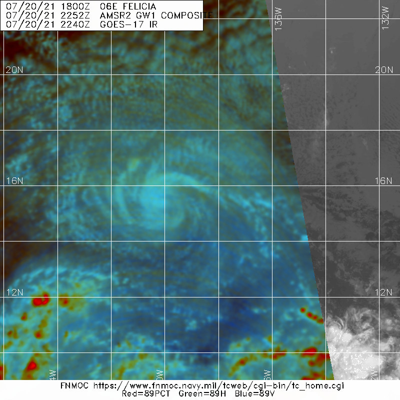
Convection once again has mostly dissipated near the low-level
circulation of Felicia. Without any organized deep convection, the
clock is now ticking on its remaining lifespan as a tropical
cyclone. An ASCAT-A scatterometer pass that was recently received at
1709 UTC had a peak wind retrieval of 32-kt just north of the
center. Given the lack of convection since that time, as well as the
latest Dvorak estimates decreasing further, Felicia is being
downgraded to a tropical depression at this time with maximum
sustained winds of 30 kt. Further weakening is anticipated as
Felicia remains in a very dry, stable environment.  The depression
is forecast to degenerate into a remnant low in the next 12 hours
and open up into a trough by the end of the week, well south of
Hawaii.

The latest estimated motion is now to the west-southwest at 255/14
kt. The track philosophy has changed little this advisory as a large
subtropical ridge will continue to steer Felicia to the
west-southwest over the last few days of its life. The latest NHC
track forecast is largely an update of the previous forecast track
as the guidance remains tightly clustered along the forecast track.
On this track, Felicia will be crossing into the central Pacific
basin within the next few hours.

This is the last advisory issued by the National Hurricane Center
on Felicia. Future information on this system can be found in
Forecast/Advisories issued by the Central Pacific Hurricane Center
beginning at 0300 UTC...under AWIPS header HFOTCMCP1 ...WMO header
WTPA21 PHFO.


FORECAST POSITIONS AND MAX WINDS

INIT  20/2100Z 15.3N 139.4W   30 KT  35 MPH
12H  21/0600Z 14.8N 141.6W   25 KT  30 MPH...POST-TROP/REMNT LOW
24H  21/1800Z 14.3N 144.4W   25 KT  30 MPH...POST-TROP/REMNT LOW
36H  22/0600Z 13.7N 147.3W   25 KT  30 MPH...POST-TROP/REMNT LOW
48H  22/1800Z 13.2N 150.0W   25 KT  30 MPH...POST-TROP/REMNT LOW
60H  23/0600Z...DISSIPATED

$$
Forecaster Papin/Cangialosi
204759_5day_cone_no_line_and_wind.png
回復

使用道具 舉報

簽到天數: 1650 天

[LV.Master]伴壇終老

老農民版夜神月|2021-7-21 10:40 | 顯示全部樓層
本帖最後由 老農民版夜神月 於 2021-7-23 05:14 編輯

CPHC首報即旋即判定其已成為殘餘低氣壓,首報成為終報
同時也為2021年來首個東太MH一生畫下句號
WTPN31 PHNC 210400 AMD
MSGID/GENADMIN/JOINT TYPHOON WRNCEN PEARL HARBOR HI//
SUBJ/TROPICAL DEPRESSION 06E (FELICIA) WARNING NR 028A AMENDED//
RMKS/
1. TROPICAL DEPRESSION 06E (FELICIA) WARNING NR 028A AMENDED
   02 ACTIVE TROPICAL CYCLONES IN EASTPAC
   MAX SUSTAINED WINDS BASED ON ONE-MINUTE AVERAGE
   WIND RADII VALID OVER OPEN WATER ONLY
    ---
   WARNING POSITION:
   210000Z --- NEAR 15.1N 140.2W
     MOVEMENT PAST SIX HOURS - 255 DEGREES AT 15 KTS
     POSITION ACCURATE TO WITHIN 060 NM
     POSITION BASED ON CENTER LOCATED BY SATELLITE
   PRESENT WIND DISTRIBUTION:
   MAX SUSTAINED WINDS - 030 KT, GUSTS 040 KT
   WIND RADII VALID OVER OPEN WATER ONLY
   POST-TROP/REMNT LOW
   REPEAT POSIT: 15.1N 140.2W
    ---
   FORECASTS:
   12 HRS, VALID AT:
   211200Z --- 14.5N 143.0W
   MAX SUSTAINED WINDS - 025 KT, GUSTS 035 KT
   WIND RADII VALID OVER OPEN WATER ONLY
   POST-TROP/REMNT LOW
   VECTOR TO 24 HR POSIT: 255 DEG/ 13 KTS
    ---
   24 HRS, VALID AT:
   220000Z --- 13.9N 145.7W
   MAX SUSTAINED WINDS - 025 KT, GUSTS 035 KT
   WIND RADII VALID OVER OPEN WATER ONLY
   POST-TROP/REMNT LOW
   VECTOR TO 36 HR POSIT: 260 DEG/ 14 KTS
    ---
   36 HRS, VALID AT:
   221200Z --- 13.3N 148.5W
   MAX SUSTAINED WINDS - 025 KT, GUSTS 035 KT
   WIND RADII VALID OVER OPEN WATER ONLY
   POST-TROP/REMNT LOW
   VECTOR TO 48 HR POSIT: 265 DEG/ 14 KTS
    ---
   EXTENDED OUTLOOK:
   48 HRS, VALID AT:
   230000Z --- 13.0N 151.4W
   MAX SUSTAINED WINDS - 025 KT, GUSTS 035 KT
   WIND RADII VALID OVER OPEN WATER ONLY
   POST-TROP/REMNT LOW
    ---
REMARKS:
210400Z POSITION NEAR 14.9N 141.1W.
21JUL21. TROPICAL DEPRESSION 06E (FELICIA), LOCATED APPROXIMATELY
896 NM EAST-SOUTHEAST OF HILO, HAS TRACKED WEST-SOUTHWESTWARD AT
15 KNOTS OVER THE PAST SIX HOURS.
THIS IS THE FINAL WARNING ON THIS SYSTEM BY THE JOINT TYPHOON
WRNCEN PEARL HARBOR HI. THE SYSTEM WILL BE CLOSELY MONITORED FOR
SIGNS OF REGENERATION. MAXIMUM SIGNIFICANT WAVE HEIGHT AT 210000Z
IS 8 FEET.
REFER TO TROPICAL CYCLONE 07E (GUILLERMO) WARNINGS (WTPN32 PGTW)
FOR SIX-HOURLY UPDATES.
2. JUSTIFICATION FOR AMENDMENT: UPDATED TO REFLECT FINAL WARNING FOR
TD 06E.//
NNNN
000
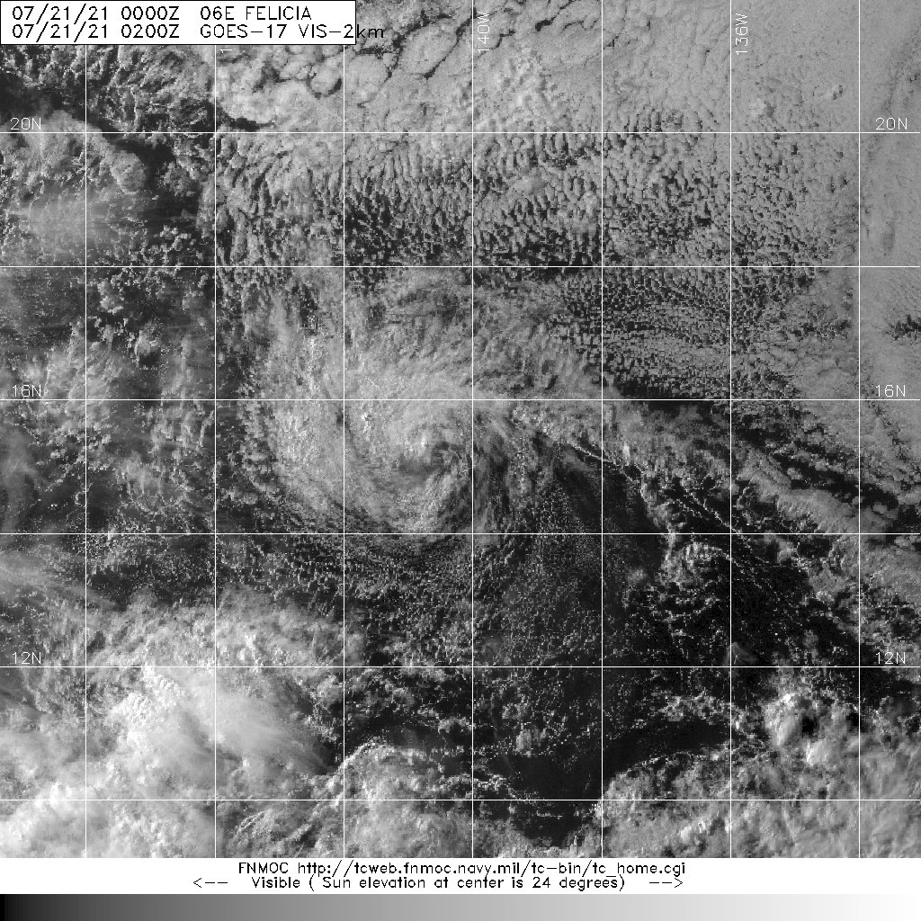
WTPA41 PHFO 210234
TCDCP1

Post-Tropical Cyclone Felicia Discussion Number  28
NWS Central Pacific Hurricane Center Honolulu HI   EP062021
500 PM HST Tue Jul 20 2021

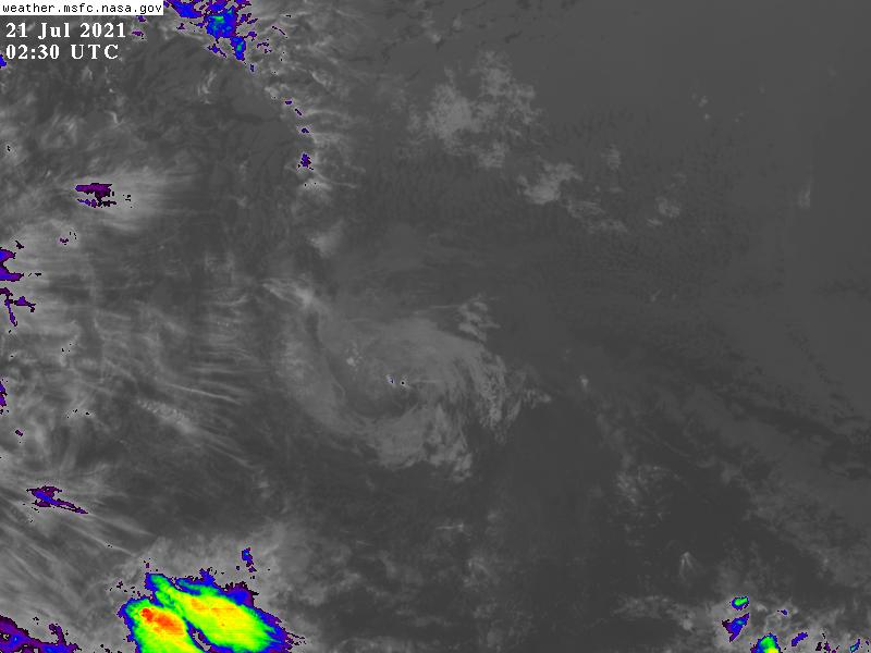
A small area of deep convection that flared up early this morning
has dissipated. Since then, what's left of Felicia is just a low
cloud swirl moving within the trade wind flow, with thin high clouds
moving over it from the west. The initial motion is 255/14 kt.
Felicia is moving in a hostile environment, with dry, stable
conditions, vertical wind shear greater than 20 kt, and sea
surface temperatures around 25 to 26C. While there may be isolated
flare-ups of deep convection over the next couple of days,
reintensification under these conditions is not likely. Thus,
Felicia has been declared a post-tropical remnant low. The remnant
circulation of Felicia should continue to spin down and the global
models open up the circulation into a trough by the end of the week.

This is the last advisory issued by the Central Pacific Hurricane
Center on Felicia. Additional information on this system can be
found in the High Seas Forecasts issued by the National Weather
Service in Honolulu under AWIPS header HFOHSFNP and WMO header
FZPN40 PHFO.


FORECAST POSITIONS AND MAX WINDS

INIT  21/0300Z 14.9N 140.9W   30 KT  35 MPH...POST-TROP/REMNT LOW
12H  21/1200Z 14.5N 143.0W   25 KT  30 MPH...POST-TROP/REMNT LOW
24H  22/0000Z 13.9N 145.7W   25 KT  30 MPH...POST-TROP/REMNT LOW
36H  22/1200Z 13.3N 148.5W   25 KT  30 MPH...POST-TROP/REMNT LOW
48H  23/0000Z 13.0N 151.4W   25 KT  30 MPH...POST-TROP/REMNT LOW
60H  23/1200Z...DISSIPATED

$$
Forecaster Kodama
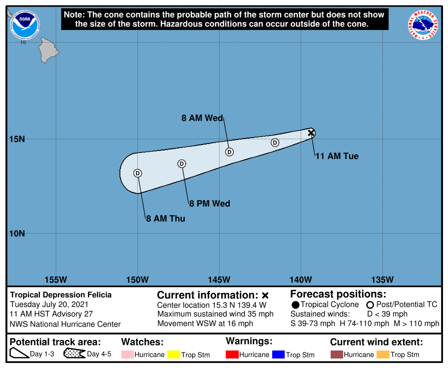
023536_5day_cone_no_line_and_wind.png 20210721.0200.goes-17.vis.2km.06E.FELICIA.30kts.1008mb.15.1N.140.2W.pc.jpg

20210720.2252.gw1.89pct89h89v.06E.FELICIA.30kts.1008mb.15.5N.138.7W.76pc.jpg GOES02302021202Ukp9mB.jpg
回復

使用道具 舉報

123
快速回覆
您需要登錄後才可以回帖 登錄 | 立即加入

本版積分規則

本平台僅供學術討論之用,預報應以氣象局為準

威普網站虛擬主機贊助公司

臺灣第一個天氣類型社群平台 即時天氣資訊、精準颱風動態

線上客服
FB傳送訊息
廣告行銷
精準行銷 物超所值
官方粉專
發佈 快速回復 返回頂部 返回列表