開啟輔助訪問
 找回密碼
 立即加入

14E.Nora 登陸墨西哥

簽到天數: 1650 天

[LV.Master]伴壇終老

老農民版夜神月|2021-8-28 18:53 | 顯示全部樓層
NHC升格C1
FORECAST POSITIONS AND MAX WINDS

INIT  28/0900Z 17.1N 105.2W   65 KT  75 MPH
12H  28/1800Z 18.8N 105.5W   75 KT  85 MPH
24H  29/0600Z 20.8N 106.1W   75 KT  85 MPH...NEAR MAINLAND MEXICO
36H  29/1800Z 22.4N 107.0W   70 KT  80 MPH
48H  30/0600Z 23.3N 107.8W   70 KT  80 MPH
60H  30/1800Z 24.1N 108.6W   70 KT  80 MPH
72H  31/0600Z 24.9N 109.4W   70 KT  80 MPH
96H  01/0600Z 26.4N 110.6W   70 KT  80 MPH
120H  02/0600Z 28.7N 111.0W   45 KT  50 MPH...INLAND
090033_5day_cone_no_line_and_wind.png 14e_280600sair.jpg
20210828.1020.goes-16.ir.14E.NORA.65kts.983mb.16.7N.105W.100pc.jpg 20210828.0849.gw1.89pct89h89v.14E.NORA.65kts.983mb.16.7N.105W.89pc.jpg
回復

使用道具 舉報

簽到天數: 1650 天

[LV.Master]伴壇終老

老農民版夜神月|2021-8-29 02:46 | 顯示全部樓層
本帖最後由 老農民版夜神月 於 2021-8-29 03:10 編輯

路徑較前幾天預測的略微偏東,將沿墨西哥西部近海北上
由於陸地的影響,強度應該會比數值一開始高潮時預測的差了些
不得不說NHC對14E的強度預測挺準的 14E_RBTOP.png 14E_BAND01.gif
20210828.1600.gpm.89hbt.14E.NORA.70kts.981mb.17.8N.105.3W.060pc.jpg 20210828.1600.gpm.89pct89h89v.14E.NORA.70kts.981mb.17.8N.105.3W.060pc.jpg

下載.png
回復

使用道具 舉報

簽到天數: 1650 天

[LV.Master]伴壇終老

老農民版夜神月|2021-8-29 07:00 | 顯示全部樓層
似乎已經登陸墨西哥 14E_RBTOP.gif 14E_BAND01 (2).gif
14E_BD.gif
回復

使用道具 舉報

簽到天數: 1650 天

[LV.Master]伴壇終老

老農民版夜神月|2021-8-30 01:58 | 顯示全部樓層
本帖最後由 老農民版夜神月 於 2021-8-30 01:59 編輯

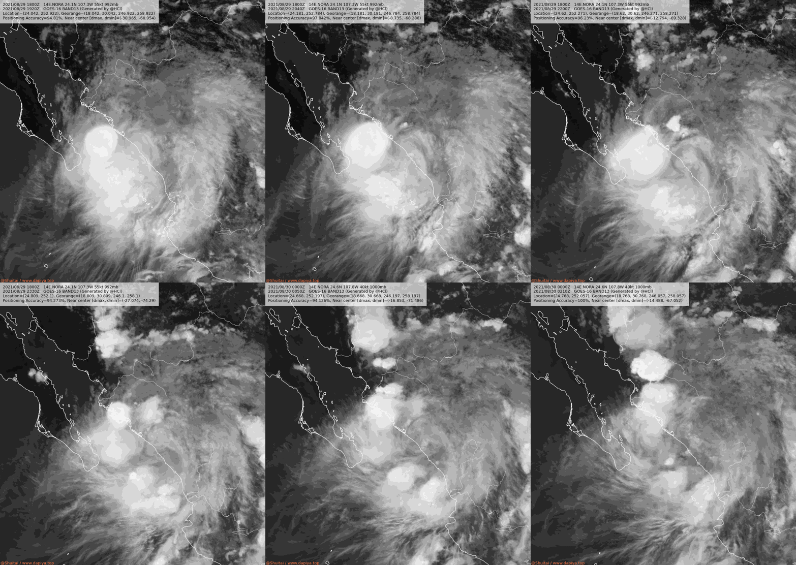
NHC18Z降格TS,其將沿墨西哥西部海岸線一路北上

144645_5day_cone_no_line_and_wind.png 14E_RBTOP (1).gif
14E_BAND13.gif 20210829.1159.f18.91h.14E.NORA.65kts.985mb.22.8N.106.1W.075pc.jpg

586
WTPZ34 KNHC 291753
TCPEP4

BULLETIN
Tropical Storm Nora Intermediate Advisory Number 16A
NWS National Hurricane Center Miami FL       EP142021
1200 PM MDT Sun Aug 29 2021

...NORA MOVING NORTHWESTWARD NEAR THE COAST OF WEST-CENTRAL
MEXICO...
...HEAVY RAINS AND FLOODING CONTINUE ACROSS PORTIONS OF
SOUTHWESTERN AND WEST-CENTRAL MEXICO...


SUMMARY OF 1200 PM MDT...1800 UTC...INFORMATION
-----------------------------------------------
LOCATION...24.1N 107.3W
ABOUT 85 MI...135 KM NW OF MAZATLAN MEXICO
ABOUT 185 MI...300 KM ENE OF CABO SAN LUCAS MEXICO
MAXIMUM SUSTAINED WINDS...70 MPH...110 KM/H
PRESENT MOVEMENT...NW OR 330 DEGREES AT 13 MPH...20 KM/H
MINIMUM CENTRAL PRESSURE...988 MB...29.18 INCHES

回復

使用道具 舉報

簽到天數: 1650 天

[LV.Master]伴壇終老

老農民版夜神月|2021-8-30 10:54 | 顯示全部樓層
由於路徑較預期的偏東,更為深入陸地,減弱的速度因此較預期的快上不少,03Z只剩下TS下限35KT 024258_5day_cone_no_line_and_wind.png 14E_BAND13 (1).gif
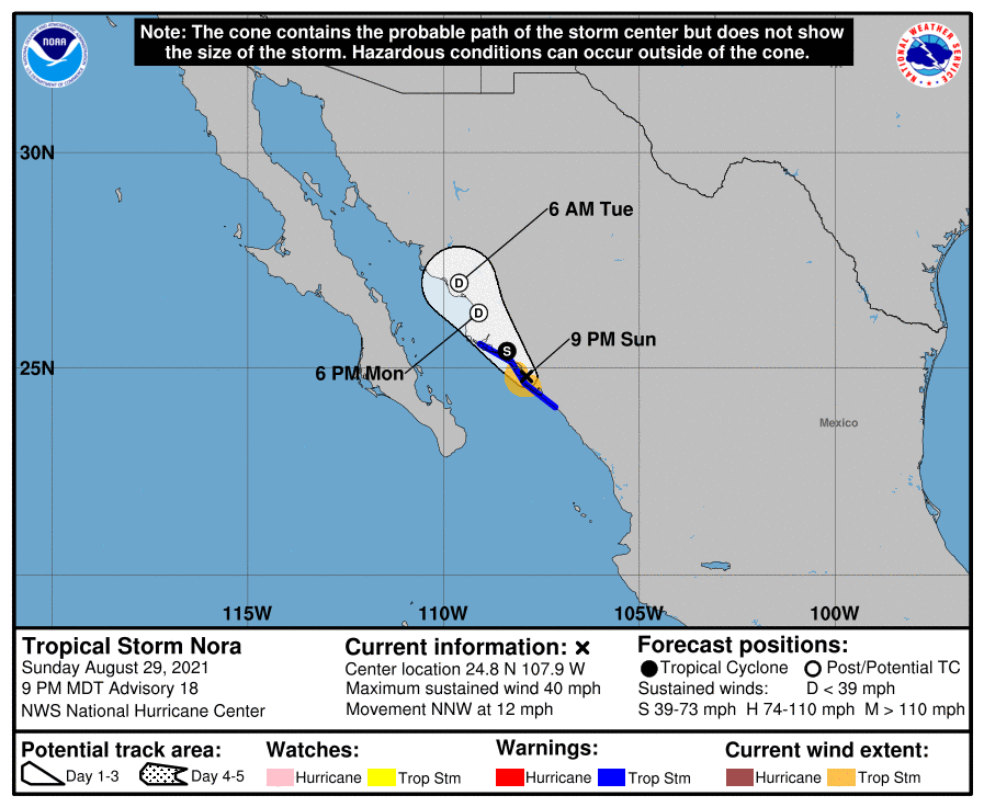
14E_CA.gif

000
WTPZ44 KNHC 300241
TCDEP4

Tropical Storm Nora Discussion Number  18
NWS National Hurricane Center Miami FL       EP142021
900 PM MDT Sun Aug 29 2021

Nora appears to have moved inland, and it is unclear if it still has
a well-defined surface center. Earlier microwave data was
inconclusive regarding the existence of the low level center, while
the Dvorak analysts from TAFB and SAB were each unable to fix Nora's
center over water. The intensity has been lowered to 35 kt, assuming
weakening has occurred due to continued interaction with land.
Baring an unexpected redevelopment of the center over water, Nora
should continue to weaken inland, and could dissipate as soon as
early Monday. Quick dissipation is now supported by all of the
dynamical guidance. Accordingly, the NHC intensity forecast has
been adjusted much lower than in the previous advisory. Nora
is forecast to become post-tropical tomorrow and dissipate by
Tuesday. Based on recent trends, this forecast is probably generous.

Despite the uncertainty associated with Nora's position, the system
still appears to be moving generally north-northwestward, with an
initial motion of 330/10 kt. None of the dynamical guidance is able
to track a low-level center more than about 24 h. However,there is
good agreement that the mid-level remnants of Nora will continue
moving generally northwestward and could contribute to heavy rain
across northwest Mexico and portions of the southwestern U.S. during
the middle to latter portion of the week.

Key Messages:

1. Heavy rain associated with Nora is expected across the west
coast of Mexico from the states of Nayarit northward to southern
Sonora.  This rain will likely result in life-threatening flash
flooding and mudslides across these regions. Rainfall from Nora is
likely to spread into the southwestern U.S. and central Rockies
during the middle to latter portion of the week, bringing the
potential for flash flooding to the region


FORECAST POSITIONS AND MAX WINDS

INIT  30/0300Z 24.8N 107.9W   35 KT  40 MPH
12H  30/1200Z 25.4N 108.4W   35 KT  40 MPH...INLAND
24H  31/0000Z 26.3N 109.1W   30 KT  35 MPH...POST-TROP/INLAND
36H  31/1200Z 27.0N 109.6W   25 KT  30 MPH...POST-TROP/INLAND
48H  01/0000Z...DISSIPATED

$$
Forecaster D. Zelinsky
回復

使用道具 舉報

簽到天數: 1650 天

[LV.Master]伴壇終老

老農民版夜神月|2021-8-30 13:49 | 顯示全部樓層
NHC降格TD
004
WTPZ34 KNHC 300532
TCPEP4

BULLETIN
Tropical Depression Nora Intermediate Advisory Number 18A
NWS National Hurricane Center Miami FL       EP142021
1200 AM MDT Mon Aug 30 2021

...NORA WEAKENS TO A DEPRESSION...
...HEAVY RAINS WILL CONTINUE TO SPREAD NORTHWARD ACROSS NORTHWEST
MEXICO DURING THE NEXT COUPLE OF DAYS...


SUMMARY OF 1200 AM MDT...0600 UTC...INFORMATION
-----------------------------------------------
LOCATION...25.0N 108.0W
ABOUT 85 MI...135 KM SE OF LOS MOCHIS MEXICO
MAXIMUM SUSTAINED WINDS...35 MPH...55 KM/H
PRESENT MOVEMENT...NNW OR 335 DEGREES AT 12 MPH...19 KM/H
MINIMUM CENTRAL PRESSURE...1004 MB...29.65 INCHES
20210830.0119.f17.91pct91h91v.14E.NORA.40kts.1000mb.24.6N.107.8W.090pc.jpg 20210830.0119.f17.91h.14E.NORA.40kts.1000mb.24.6N.107.8W.090pc.jpg
回復

使用道具 舉報

簽到天數: 1650 天

[LV.Master]伴壇終老

老農民版夜神月|2021-8-30 19:34 | 顯示全部樓層
NHC09Z停編 floater_floater_EP142021_Sandwich_24fr_20210830-0733.gif 085304_5day_cone_no_line_and_wind.png

000
WTPZ44 KNHC 300852
TCDEP4

Remnants Of Nora Discussion Number  19
NWS National Hurricane Center Miami FL       EP142021
300 AM MDT Mon Aug 30 2021

Satellite analysts have been unable to identify a low-level center
associated with Nora, and scatterometer and synoptic data show no
surface circulation.  Therefore the system has dissipated and this
is the last advisory on this system. However, the moisture field of
Nora's remnants will continue to move poleward over the next few
days and could contribute to rainfall enhancement over the
southwestern United States later this week.

Key Messages:

1. Heavy rain associated with Nora's remnants is expected across
the states of Sinaloa and Sonora.  This rain will likely result in
life-threatening flash flooding and mudslides.  Rainfall from the
remnants of Nora is also likely to spread into the southwestern
U.S. and central Rockies beginning Wednesday, bringing the potential
for flash flooding to the region.

FORECAST POSITIONS AND MAX WINDS

INIT  30/0900Z 25.3N 108.1W   25 KT  30 MPH
12H  30/1800Z...DISSIPATED

$$
Forecaster Pasch
回復

使用道具 舉報

12
快速回覆
您需要登錄後才可以回帖 登錄 | 立即加入

本版積分規則

本平台僅供學術討論之用,預報應以氣象局為準

威普網站虛擬主機贊助公司

臺灣第一個天氣類型社群平台 即時天氣資訊、精準颱風動態

線上客服
FB傳送訊息
廣告行銷
精準行銷 物超所值
官方粉專
發佈 快速回復 返回頂部 返回列表