|
|
 天篷大元帥|2021-9-10 23:23
|
顯示全部樓層
天篷大元帥|2021-9-10 23:23
|
顯示全部樓層
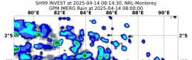
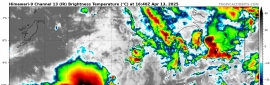
結構受地形的破壞,已經減弱為熱帶風暴。
國家颶風中心報文原文:
Tropical Storm Olaf Discussion Number 12
NWS National Hurricane Center Miami FL EP152021
900 AM MDT Fri Sep 10 2021
The satellite presentation of Olaf has significantly degraded over
the past several hours after the center moved across the southern
portion of Baja California Sur overnight. The system's organized
convection has collapsed, and infrared satellite imagery indicates
cloud top temperatures are rapidly warming near the estimated center
position. The initial intensity is lowered to 60 kt for this
advisory, which now makes Olaf a tropical storm. This estimate may
still be generous, but limited surface observations and radar data
make it difficult to confidently assess the intensity. Hopefully,
scatterometer data this afternoon will provide more insight into
changes in Olaf's surface wind field.
The tropical storm has slowed down a bit since last night, and its
estimated motion is northwest (310 degrees) at 9 kt. Recent
microwave imagery suggests the center of Olaf is just offshore the
southwestern coast of Baja California Sur, and the cyclone is likely
to move roughly parallel to the coast today. Then, a strong
mid-level high pressure ridge centered over the southern Rockies is
expected to build westward to the north of Olaf. This ridge should
turn Olaf toward the west by tonight, and then toward the southwest
through early next week. The official NHC track forecast has been
adjusted to the south of the previous forecast once again, in
agreement with the latest multi-model consensus aids.
Olaf is likely to continue rapidly weakening during the next couple
of days. In the short-term, its proximity to the mountainous terrain
of the Baja California peninsula will disrupt its ability to sustain
organized convection. As Olaf moves away from land, the cyclone will
encounter decreasing sea-surface temperatures and very dry mid-level
air, which should expedite its transition into a post-tropical
cyclone. In fact, the latest GFS and ECMWF model simulated satellite
imagery show Olaf becoming completely devoid of convection within
the next 24-36 h. The latest NHC intensity forecast shows more rapid
weakening than the previous one, primarily based on recent satellite
trends and the lower initial intensity. The official forecast
remains below the HCCA and IVCN consensus aids, which are inflated
by the SHIPS and LGEM models that fail to weaken Olaf during the
next 24 h.
Key Messages:
1. Olaf is forecast to move along the southwestern coast of the
Baja California peninsula today, with tropical storm conditions
continuing over southern portions of Baja California Sur through
this evening. These winds should diminish tonight as Olaf continues
weakening and turns westward away from land.
2. Heavy rains associated with Olaf are expected across portions of
southern Baja California Sur through today. This will pose a threat
of significant and life-threatening flash flooding and mudslides.
FORECAST POSITIONS AND MAX WINDS
INIT 10/1500Z 24.1N 111.3W 60 KT 70 MPH
12H 11/0000Z 24.5N 112.4W 50 KT 60 MPH
24H 11/1200Z 24.6N 113.6W 40 KT 45 MPH
36H 12/0000Z 24.3N 114.7W 35 KT 40 MPH...POST-TROPICAL
48H 12/1200Z 23.4N 115.9W 30 KT 35 MPH...POST-TROP/REMNT LOW
60H 13/0000Z 22.4N 117.3W 25 KT 30 MPH...POST-TROP/REMNT LOW
72H 13/1200Z 21.6N 118.6W 25 KT 30 MPH...POST-TROP/REMNT LOW
96H 14/1200Z 20.7N 121.0W 20 KT 25 MPH...POST-TROP/REMNT LOW
120H 15/1200Z 20.0N 123.0W 20 KT 25 MPH...POST-TROP/REMNT LOW
$$
Forecaster Reinhart
熱帶風暴奧拉夫討論號 12
NWS 國家颶風中心佛羅里達州邁阿密 EP152021
2021 年 9 月 10 日星期五上午 900 MDT
Olaf 的衛星顯示已顯著降低
在中心穿過南部的過去幾個小時
一夜之間南下加利福尼亞州的一部分。系統有組織
對流已經瓦解,紅外衛星圖像顯示
估計中心附近的雲頂溫度正在迅速升溫
位置。為此,初始強度降低到 60 kt
諮詢,現在使奧拉夫成為熱帶風暴。這個估計可能
仍然慷慨,但有限的地面觀測和雷達數據
很難自信地評估強度。希望,
今天下午的散射計數據將提供更深入的了解
奧拉夫表面風場的變化。
熱帶風暴自昨晚以來有所減弱,其
估計的運動是西北(310 度),速度為 9 節。最近的
微波圖像表明奧拉夫的中心就在海面
南下加利福尼亞州西南海岸,氣旋很可能
今天大致平行於海岸移動。然後,一個強
以落基山脈南部為中心的中層高壓脊是
預計將向西建造到奧拉夫以北。這個脊應該
今晚前將奧拉夫轉向西方,然後轉向西南
通過下周初。 NHC 的官方軌道預測是
再次調整到之前預測的南部,在
與最新的多模型共識輔助工具一致。
奧拉夫在接下來的日子裡很可能會繼續迅速走弱
天。從短期來看,它靠近山區
下加利福尼亞半島的破壞將破壞其維持的能力
有組織的對流。當奧拉夫離開陸地時,氣旋將
遇到降低的海面溫度和非常乾燥的中層
空氣,這將加速其向後熱帶氣候的轉變
氣旋。事實上,最新的GFS和ECMWF模型模擬衛星
圖像顯示奧拉夫內部完全沒有對流
接下來的 24-36 小時。最新的NHC強度預測顯示更快
比上一次減弱,主要基於最近的衛星
趨勢和較低的初始強度。官方預測
仍然低於 HCCA 和 IVCN 共識援助,它們被誇大了
由 SHIPS 和 LGEM 模型未能削弱奧拉夫在
下一個 24 小時。
關鍵信息:
1. 預計奧拉夫將沿著西南海岸移動
今天的下加利福尼亞半島,有熱帶風暴條件
繼續在南下加利福尼亞州南部通過
今天晚上。隨著奧拉夫的繼續,今晚這些風應該會減弱
減弱並向西遠離陸地。
2. 預計部分地區將出現與奧拉夫相關的大雨
南下加利福尼亞州南部一直到今天。這將構成威脅
重大和危及生命的山洪暴發和泥石流。
預測位置和最大風力
INIT 10/1500Z 24.1N 111.3W 60 KT 70 MPH
12H 11/0000Z 24.5N 112.4W 50 KT 60 MPH
24H 11/1200Z 24.6N 113.6W 40 KT 45 MPH
36H 12/0000Z 24.3N 114.7W 35 KT 40 MPH...後熱帶
48H 12/1200Z 23.4N 115.9W 30 KT 35 MPH...POST-TROP/REMNT LOW
60H 13/0000Z 22.4N 117.3W 25 KT 30 MPH...POST-TROP/REMNT LOW
72H 13/1200Z 21.6N 118.6W 25 KT 30 MPH...POST-TROP/REMNT LOW
96H 14/1200Z 20.7N 121.0W 20 KT 25 MPH...POST-TROP/REMNT LOW
120H 15/1200Z 20.0N 123.0W 20 KT 25 MPH...POST-TROP/REMNT LOW
$$
預報員萊因哈特
|
|