開啟輔助訪問
 找回密碼
 立即加入

20S.Billy 短暫發展

簽到天數: 2414 天

[LV.Master]伴壇終老

2022-3-11 23:06 | 顯示全部樓層
本帖最後由 周子堯@FB 於 2022-3-18 16:39 編輯

基本資料  
編號    :20 S
擾動編號日期:2022 03 11 09
撤編日期  :2022 03 18 06
90S.INVEST.15kts.1006mb.10.4S.111.3E

20220311.0110.himawari-8.ircolor.90S.INVEST.15kts.1006mb.10.4S.111.3E.100pc.jpg

評分

參與人數 1水氣能量 +15 +1 收起 理由
t02436 + 15 + 1

查看全部評分

回復

使用道具 舉報

簽到天數: 3291 天

[LV.Master]伴壇終老

t02436|2022-3-14 16:10 | 顯示全部樓層
18Z已升格20S,巔峰上望50節。
sh202022.20220314064049.gif

20220314.0740.himawari-8.vis.20S.TWENTY.45kts.998mb.15.3S.100.6E.100pc.jpg
回復

使用道具 舉報

簽到天數: 2141 天

[LV.Master]伴壇終老

周子堯@FB|2022-3-14 16:33 | 顯示全部樓層
補BOM編號報文
IDW23100

40:2:2:24:12S105E400:11:00
SECURITE

OCEAN WIND WARNING FOR METAREA 10
Issued by the Australian Bureau of Meteorology
Tropical Cyclone Warning Centre
at 0637 UTC 13 MARCH 2022

GALE WARNING

Please be aware, wind gusts can be a further 40 percent stronger than the
averages given here, and maximum waves may be up to twice the height.

SITUATION
At 0600 UTC a Tropical Low was centred within 45 nautical miles of
latitude twelve decimal five south (12.5S)
longitude one hundred and five decimal zero east (105.0E)
Recent movement : southwest at 11 knots
Maximum winds   : 25 knots
Central pressure: 1002 hPa
The low is not expected to develop into a tropical cyclone in the next 24
hours, however gales may develop in the southern semicircle after 0000 UTC 14
March.

AREA AFFECTED
Within 90 nautical miles of the centre in the southern semicircle after 0000
UTC 14 March.

FORECAST
Maximum winds to 25 knots near the centre increasing to 35 knots after 0000 UTC
14 March.

After 0000 UTC 14 March winds above 34 knots within 90 nautical miles of centre
in the southern semicircle, with rough seas and moderate swell.

Forecast positions
At 1800 UTC 13 March: Within 65 nautical miles of 13.5 south 103.2 east
                        Central pressure 1002 hPa.
                        Winds to 30 knots near centre.
At 0600 UTC 14 March: Within 70 nautical miles of 14.6 south 101.1 east
                        Central pressure 999 hPa.
                        Winds to 35 knots near centre.

REMARKS
All ships in the area please send weather reports every three hours.
Regular weather observing ships use normal channels.
Other ships please use email to tcwc@bom.gov.au.

Next warning will be issued by 1300 UTC 13 March 2022.

AUSTRALIAN BUREAU OF METEOROLOGY
TROPICAL CYCLONE WARNING CENTRE
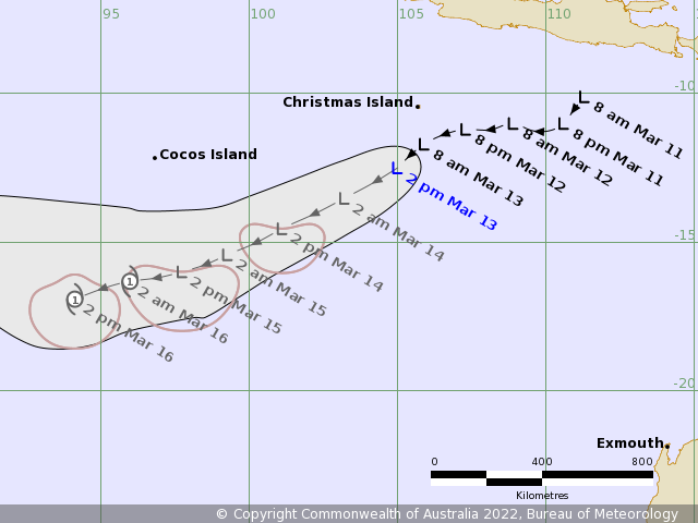
145029qu668cmp74pnimcn.png
Time (AWST)        Intensity Category        Latitude
(decimal deg.)        Longitude
(decimal deg.)        Estimated Position
Accuracy (km)
0hr        2 pm March 13        tropical low        12.5S        105.0E        85
+6hr        8 pm March 13        tropical low        13.0S        104.1E        110
+12hr        2 am March 14        tropical low        13.5S        103.2E        125
+18hr        8 am March 14        tropical low        14.1S        102.2E        125
+24hr        2 pm March 14        tropical low        14.6S        101.1E        130
+36hr        2 am March 15        tropical low        15.4S        99.3E        135
+48hr        2 pm March 15        tropical low        16.0S        97.7E        170
+60hr        2 am March 16        1        16.3S        96.0E        215
+72hr        2 pm March 16        1        16.9S        94.1E        270


回復

使用道具 舉報

簽到天數: 2141 天

[LV.Master]伴壇終老

周子堯@FB|2022-3-15 17:07 | 顯示全部樓層
15/00Z BOM終於命名Billy,並預計未來12小時,維持澳式C1
IDW27600
TROPICAL CYCLONE TECHNICAL BULLETIN: AUSTRALIA - WESTERN REGION
Issued by AUSTRALIAN BUREAU OF METEOROLOGY TROPICAL CYCLONE WARNING CENTRE
at: 0059 UTC 15/03/2022
Name: Tropical Cyclone Billy
Identifier: 27U
Data At: 0000 UTC
Latitude: 16.6S
Longitude: 98.3E
Location Accuracy: within 30nm (55 km)
Movement Towards: west southwest (244 deg)
Speed of Movement: 7 knots (13 km/h)
Maximum 10-Minute Wind: 45 knots (85 km/h)
Maximum 3-Second Wind Gust: 65 knots (120 km/h)
Central Pressure: 991 hPa
Radius of 34-knot winds NE quadrant:
Radius of 34-knot winds SE quadrant: 120 nm (220 km)
Radius of 34-knot winds SW quadrant: 120 nm (220 km)
Radius of 34-knot winds NW quadrant: 60 nm (110 km)
Radius of 48-knot winds NE quadrant:
Radius of 48-knot winds SE quadrant:
Radius of 48-knot winds SW quadrant:
Radius of 48-knot winds NW quadrant:
Radius of 64-knot winds:  nm ( km)
Radius of Maximum Winds: 30 nm (55 km)
Dvorak Intensity Code: T2.5/2.5/D0.5/24HRS STT:S0.0/06HRS
Pressure of outermost isobar: 1005 hPa
Radius of outermost closed isobar: 100 nm (185 km)
FORECAST DATA
Date/Time    : Location    : Loc. Accuracy: Max Wind   : Central Pressure
(UTC)        : degrees     :      nm  (km): knots(km/h): hPa
+06:  15/0600: 16.9S  97.4E:     045 (080):  045  (085):  992
+12:  15/1200: 17.0S  96.7E:     045 (080):  045  (085):  992
+18:  15/1800: 17.1S  95.6E:     055 (100):  040  (075):  995
+24:  16/0000: 17.3S  94.4E:     065 (125):  040  (075):  995
+36:  16/1200: 18.2S  92.6E:     100 (185):  035  (065):  998
+48:  17/0000: 19.3S  91.2E:     125 (230):  035  (065):  997
+60:  17/1200: 19.9S  90.1E:     160 (295):  030  (055): 1000
+72:  18/0000: 19.9S  88.3E:     190 (355):  025  (045): 1004
+96:  19/0000:             :              :            :     
+120: 20/0000:             :              :            :     
REMARKS:
Tropical Cyclone Billy has been named but it's time at TC strength is likely to
be short lived.

The centre has been located using recent MW and animated IR imagery.

Dvorak analysis has a DT 2.5 with a wrap of 0.4, though doesn't have classic
curvature. MET is 2.0 and PAT 2.5. FT/CI 2.5 based on PAT. SATCON has 60 knots.
NOAA and CIMSS ADT both have CI 3.5 and Vmax 55 knots. AiDT is 48 knots. An
AMSR pass at 1814Z suggested winds in the southern quadrants in excess of 50
knots but confined to southern quadrants. Final intensity is set to 45 knots
(10-min mean). With deep convection becoming more prominent in the NW quadrant,
the system has been analysed to now have gales extending into that area and
hence has been named.

Warm SST above 28C. Shear is low with an upper level anticyclone over the top.
Poleward outflow channel continues and the equatorward outflow maintaining
itself over the last six hours. In the mid levels, winds are NE'ly (resulting
in the W-SW forecast motion). The environment is moderately favourable but
begins to deteriorate later on Tuesday when the shear increases and the dry air
(to the west) starts impacting the system.

Copyright Commonwealth of Australia
==
The next bulletin for this system will be issued by: 15/0730 UTC.
085559qztkk5qq40943mr4.png
Time (AWST)        Intensity Category        Latitude
(decimal deg.)        Longitude
(decimal deg.)        Estimated Position
Accuracy (km)
0hr        8 am March 15        1        16.6S        98.3E        55
+6hr        2 pm March 15        1        16.9S        97.4E        80
+12hr        8 pm March 15        1        17.0S        96.7E        80
+18hr        2 am March 16        1        17.1S        95.6E        100
+24hr        8 am March 16        1        17.3S        94.4E        125
+36hr        8 pm March 16        tropical low        18.2S        92.6E        185
+48hr        8 am March 17        tropical low        19.3S        91.2E        230
+60hr        8 pm March 17        tropical low        19.9S        90.1E        295
+72hr        8 am March 18        tropical low        19.9S        88.3E        355

20220315.0830.himawari-8.vis.20S.BILLY.55kts.993mb.17S.97.2E.100pc.jpg
回復

使用道具 舉報

快速回覆
您需要登錄後才可以回帖 登錄 | 立即加入

本版積分規則

0908morakot

    主題

    帖子

    69萬

    積分

    12級[颶風Hurricane]

    Rank: 12Rank: 12Rank: 12

12級[颶風Hurricane]

發訊息

本平台僅供學術討論之用,預報應以氣象局為準

威普網站虛擬主機贊助公司

臺灣第一個天氣類型社群平台 即時天氣資訊、精準颱風動態

線上客服
FB傳送訊息
廣告行銷
精準行銷 物超所值
官方粉專
發佈 快速回復 返回頂部 返回列表