簽到天數: 971 天 [LV.10]以壇為家III
|
 jwpk9899|2013-10-9 23:08
|
顯示全部樓層
jwpk9899|2013-10-9 23:08
|
顯示全部樓層
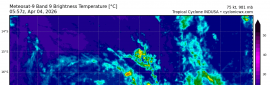
IMD升格氣旋風暴
命名PHAILIN
Time of issue: 2000 hours IST Dated: 09-10-2013
Bulletin No.: BOB 04/2013/09
Sub: Cyclonic storm, PHAILIN in East central Bay of Bengal:
Cyclone Alert for North Andhra Pradesh and Orissa Coast. Cyclone Warning for Andaman & Nicobar Island
The deep depression over east central Bay of Bengal remained practically stationery, intensified into a cyclonic storm, PHAILIN and lay centred at 1730 hrs IST of today, 09thth October 2013 over near latitude 13.50N and longitude 92.50E, about 220 km north-northwest of Port Blair, 950km southeast of Paradip, 1100 km east-southeast of Visakhapatnam. The system would intensify into a severe cyclonic storm during next 24 hours. It would continue to move west-northwestwards for some time and then northwestwards and cross north Andhra Pradesh and Odisha coast between Kalingapatnam and Paradip by night of 12thth October, 2013 as a very severe cyclonic storm with a maximum sustained wind speed of 175-185 kmph.
Squally winds speed reaching 50-60kmph gusting to 70 kmph would prevail over Andaman Nicobar Islands and adjoining sea areas during next 24 hours. Sea condition will be very rough along and off Andaman and Nicobar Islands during next 24 hrs.
|
評分
-
查看全部評分
|

 照妖鏡
照妖鏡