開啟輔助訪問
 找回密碼
 立即加入

15P.Oma 路徑迂迴 再次轉向北上

簽到天數: 868 天

[LV.10]以壇為家III

jrchang5|2019-2-21 10:33 | 顯示全部樓層
由於中心向西南移動,已通過東經160度,故自21/00Z起,將由BoM接替FMS接續發報。
目前雖朝向澳洲東岸接近,但未來路徑及強度仍有變數,對澳洲東岸影響程度仍有待觀察。
IDQ20018
TROPICAL CYCLONE TECHNICAL BULLETIN: AUSTRALIA - EASTERN REGION
Issued by BRISBANE TROPICAL CYCLONE WARNING CENTRE
at: 0140 UTC 21/02/2019
Name: Tropical Cyclone Oma
Identifier: 14U
Data At: 0000 UTC
Latitude: 22.6S
Longitude: 160.0E
Location Accuracy: within 20 nm [35 km]
Movement Towards: southwest [226 deg]
Speed of Movement: 6 knots [11 km/h]
Maximum 10-Minute Wind: 50 knots [95 km/h]
Maximum 3-Second Wind Gust: 70 knots [130 km/h]
Central Pressure: 982 hPa
Radius of 34-knot winds NE quadrant: 120 nm [220 km]
Radius of 34-knot winds SE quadrant: 150 nm [280 km]
Radius of 34-knot winds SW quadrant: 180 nm [335 km]
Radius of 34-knot winds NW quadrant: 120 nm [220 km]
Radius of 48-knot winds NE quadrant:   
Radius of 48-knot winds SE quadrant: 80 nm [150 km]
Radius of 48-knot winds SW quadrant: 90 nm [165 km]
Radius of 48-knot winds NW quadrant: 50 nm [95 km]
Radius of 64-knot winds:
Radius of Maximum Winds: 35 nm [65 km]
Dvorak Intensity Code: T3.0/3.5/W0.5/24HRS STT:S0.0/06HRS
Pressure of outermost isobar: 1004 hPa
Radius of outermost closed isobar: 370 nm [690 km]
FORECAST DATA
Date/Time    : Location    : Loc. Accuracy: Max Wind   : Central Pressure
[UTC]        : degrees     :      nm  [km]: knots[km/h]: hPa
+06:  21/0600: 23.0S 159.6E:     035 [065]:  050  [095]:  979
+12:  21/1200: 23.5S 159.2E:     045 [085]:  050  [095]:  979
+18:  21/1800: 24.0S 158.8E:     060 [110]:  050  [095]:  976
+24:  22/0000: 24.5S 158.4E:     070 [130]:  050  [095]:  975
+36:  22/1200: 25.5S 158.1E:     090 [165]:  050  [095]:  972
+48:  23/0000: 26.2S 157.8E:     120 [220]:  050  [095]:  971
+60:  23/1200: 25.8S 157.2E:     140 [255]:  050  [095]:  972
+72:  24/0000: 25.0S 156.4E:     155 [290]:  050  [095]:  976
+96:  25/0000: 23.4S 155.3E:     200 [370]:  050  [095]:  981
+120: 26/0000: 22.1S 153.8E:     290 [535]:  050  [095]:  983
REMARKS:
Tropical Cyclone Oma was located by visible imagery and has now reached the
Australian area of responsibility [160E]. The circulation has weakened as it
moves over 26-27C reflected in the reduction of deep convection. Despite that
the shear is low and poleward outflow remains strong.  
Intensity is estimated at 50 knots [category 2]. Dvorak DT=2.5 based on curved
band pattern although FT is conservatively put at 3.0 and CI held higher at 3.5.
While ASCAT has missed the area of highest winds, SCATSAT [20/1038Z] indicates
max winds of 45kn and SMAP winds [20/0754UTC] showed an area of 50+kn southwest
of the centre and max winds of 58kn.

Significantly the synoptic forcing from the subtropical ridge to the south is
expected to reinforce winds between Oma and the Australian coast extending gales
significantly during Friday and Saturday.

Model guidance is consistent with a continuing southwest track in the next
36-48h, but then the situation changes as the subtleties of the incoming
mid-level ridge diverges potential track motion. The more favoured scenario is a
northwest track that keeps Oma off the coast but sufficiently close to pose a
threat of gales along the coast.

While the circulation is likely to be hampered by SSTs of just 26C for several
days, the synoptic forcing is expected to assist in maintaining 40-50kn winds
especially southwest of the centre. In the longer term, some guidance that
tracks Oma well north suggests slight reintensification of the circulation
proper as Oma reaches warmer water.

Copyright Commonwealth of Australia
==
The next bulletin for this system will be issued by: 21/0730 UTC by Brisbane
TCWC.

IDQ65001 (1).png 20190221.0050.himawari-8.vis.15P.OMA.50kts.985mb.22.5S.160E.100pc.jpg 15P_gefs_latest.png esrl.eps.ecmb.hit.loop.15P.2019.2019022012.gif


回復

使用道具 舉報

簽到天數: 588 天

[LV.9]以壇為家II

Meow|2019-2-21 16:11 | 顯示全部樓層

2月19日強烈熱帶氣旋Oma,巔峰位處新喀里多尼亞西北方

回復

使用道具 舉報

簽到天數: 868 天

[LV.10]以壇為家III

jrchang5|2019-2-23 09:37 | 顯示全部樓層
BoM判定23/00Z轉化為副熱帶氣旋,並發出最後一報。
IDQ20018
TROPICAL CYCLONE TECHNICAL BULLETIN: AUSTRALIA - EASTERN REGION
Issued by BRISBANE TROPICAL CYCLONE WARNING CENTRE
at: 0054 UTC 23/02/2019
Name: Ex-Tropical Cyclone Oma
Identifier: 14U
Data At: 0000 UTC
Latitude: 28.3S
Longitude: 161.2E
Location Accuracy: within 20 nm [35 km]
Movement Towards: southeast [130 deg]
Speed of Movement: 9 knots [16 km/h]
Maximum 10-Minute Wind: 50 knots [95 km/h]
Maximum 3-Second Wind Gust: 70 knots [130 km/h]
Central Pressure: 980 hPa
Radius of 34-knot winds NE quadrant: 210 nm [390 km]
Radius of 34-knot winds SE quadrant: 240 nm [445 km]
Radius of 34-knot winds SW quadrant: 300 nm [555 km]
Radius of 34-knot winds NW quadrant: 210 nm [390 km]
Radius of 48-knot winds NE quadrant:   
Radius of 48-knot winds SE quadrant:   
Radius of 48-knot winds SW quadrant: 150 nm [280 km]
Radius of 48-knot winds NW quadrant:   
Radius of 64-knot winds:
Radius of Maximum Winds:   
Dvorak Intensity Code: N/A
Pressure of outermost isobar: 1004 hPa
Radius of outermost closed isobar: 270 nm [500 km]
FORECAST DATA
Date/Time    : Location    : Loc. Accuracy: Max Wind   : Central Pressure
[UTC]        : degrees     :      nm  [km]: knots[km/h]: hPa
+06:  23/0600: 28.3S 161.8E:     040 [080]:  050  [095]:  984
+12:  23/1200: 27.8S 162.1E:     055 [100]:  050  [095]:  986
+18:  23/1800: 27.0S 162.2E:     065 [125]:  045  [085]:  988
+24:  24/0000: 26.4S 162.3E:     080 [145]:  045  [085]:  990
+36:  24/1200: 24.7S 162.3E:     100 [185]:  045  [085]:  992
+48:  25/0000: 23.3S 161.8E:     120 [220]:  045  [085]:  994
+60:  25/1200: 21.6S 160.9E:     140 [255]:  045  [085]:  996
+72:  26/0000: 20.3S 159.8E:     155 [290]:  045  [085]:  996
+96:  27/0000: 18.2S 157.0E:     200 [370]:  040  [075]: 1000
+120: 28/0000: 16.4S 153.7E:     290 [535]:  030  [055]: 1002
REMARKS:
Oma has become sub-tropical and has been declassified as a Tropical Cyclone.

The circulation has lost any tropical characteristics as it moves over cooler
[25-26C] ocean temperatures and hindered by ingestion of dry air. There is now
no deep convection near the centre and Dvorak is no longer applicable. Wind
shear is moderate and poleward outflow remains strong.

Maximum winds are estimated at 50kn in the southwest quadrant based upon
scatterometry [ASCATC at 22/1135UTC] supported by model guidance. The prevailing
synoptic SE flow is enhancing winds on the southeast side which is set to
continue next week. These winds will continue to drive the significant waves
towards the southeast Queensland and far northern New South Wales coastlines.
Damaging winds extending all the way to the southeast Queensland and far
northern New South Wales coast are also still possible during the weekend.

Model guidance is consistent with a turn to the east and then to the north in
the next 24 hours as a mid-level ridge over southeastern Australia strengthens
and becomes the dominant steering mechanism. As this ridge extends into the
Tasman Sea next week the circulation should track to the northwest across the
Coral Sea.

There is a strong consensus of model guidance indicating a northward track into
next week with the system remaining well offshore from the Queensland coast over
the Coral Sea.

Synoptic forcing is expected to assist in maintaining maximum winds of 45-50
knots into early next week, especially southwest of the centre. Even when the
system moves further north towards warmer SSTs, other environmental factors come
into play such as
increasing vertical wind shear and dry air. For this reason, it is unlikely -
though not impossible - for the system to return to tropical cyclone status next
week, though it is worth noting that regardless of this, gales may persist in
southern quadrants until about Thursday.

Copyright Commonwealth of Australia
==
There will be no further bulletins for this system.

IDQ65001 (2).png 20190223.0050.himawari-8.vis.15P.OMA.35kts.996mb.28.2S.161.4E.100pc.jpg 20190223.0050.himawari-8.ir.15P.OMA.35kts.996mb.28.2S.161.4E.100pc.jpg

評分

參與人數 1水氣能量 +10 收起 理由
t02436 + 10

查看全部評分

回復

使用道具 舉報

簽到天數: 601 天

[LV.9]以壇為家II

霧峰追風者|2019-2-23 14:10 | 顯示全部樓層
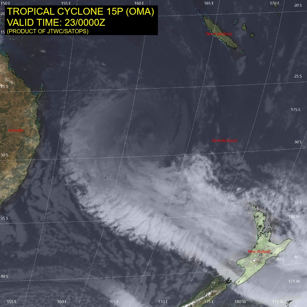
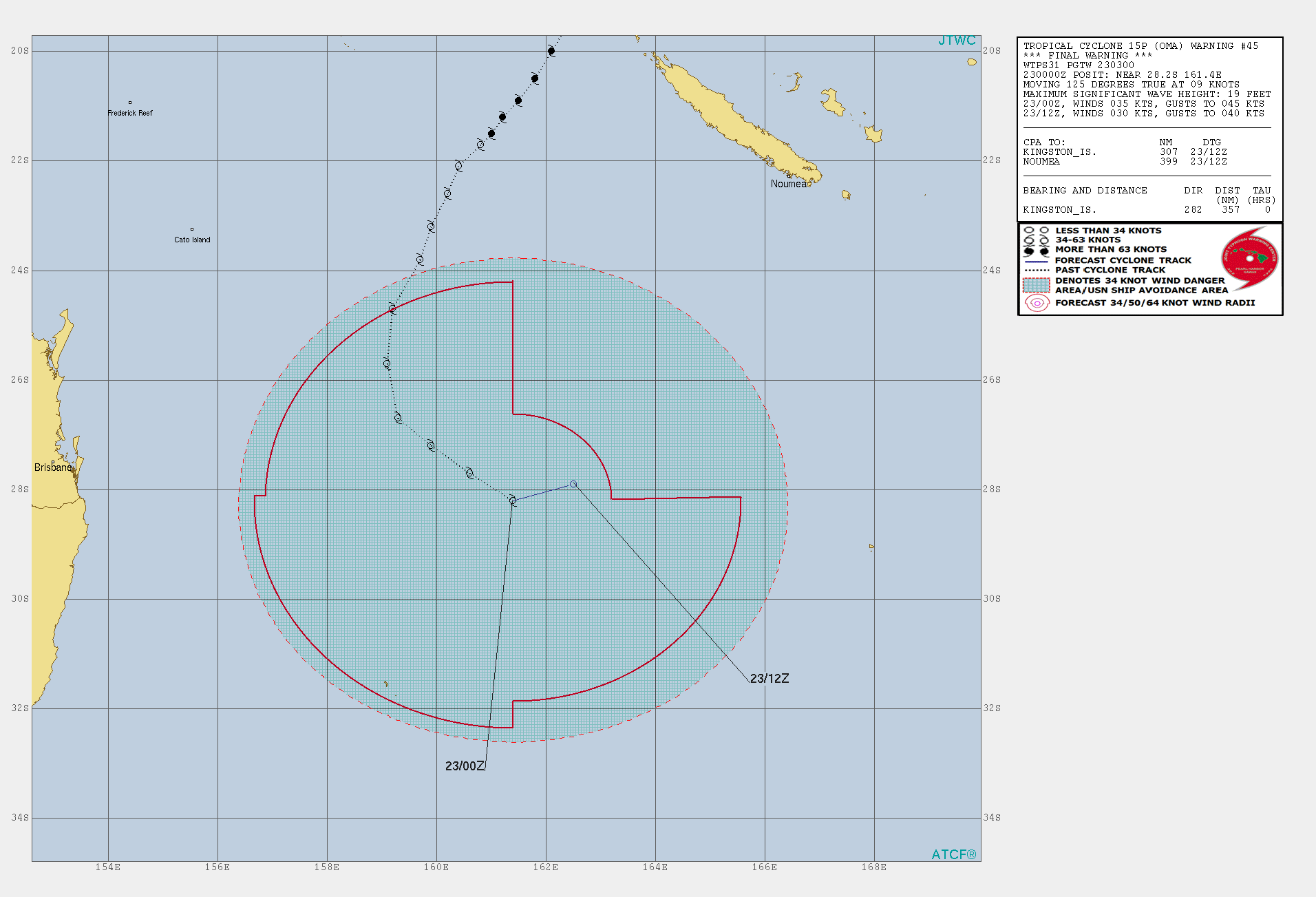
JTWC 00Z發FW
WTPS31 PGTW 230300
MSGID/GENADMIN/JOINT TYPHOON WRNCEN PEARL HARBOR HI//
SUBJ/TROPICAL CYCLONE 15P (OMA) WARNING NR 045//
RMKS/
1. TROPICAL CYCLONE 15P (OMA) WARNING NR 045   
   01 ACTIVE TROPICAL CYCLONE IN SOUTHPAC
   MAX SUSTAINED WINDS BASED ON ONE-MINUTE AVERAGE
   WIND RADII VALID OVER OPEN WATER ONLY
    ---
   WARNING POSITION:
   230000Z --- NEAR 28.2S 161.4E
     MOVEMENT PAST SIX HOURS - 125 DEGREES AT 09 KTS
     POSITION ACCURATE TO WITHIN 035 NM
     POSITION BASED ON CENTER LOCATED BY SATELLITE
   PRESENT WIND DISTRIBUTION:
   MAX SUSTAINED WINDS - 035 KT, GUSTS 045 KT
   WIND RADII VALID OVER OPEN WATER ONLY
   DISSIPATING AS A SIGNIFICANT TROPICAL CYCLONE OVER WATER
   RADIUS OF 034 KT WINDS - 095 NM NORTHEAST QUADRANT
                            220 NM SOUTHEAST QUADRANT
                            250 NM SOUTHWEST QUADRANT
                            240 NM NORTHWEST QUADRANT
   REPEAT POSIT: 28.2S 161.4E
    ---
   FORECASTS:
   12 HRS, VALID AT:
   231200Z --- 27.9S 162.5E
   MAX SUSTAINED WINDS - 030 KT, GUSTS 040 KT
   WIND RADII VALID OVER OPEN WATER ONLY
   DISSIPATED AS A SIGNIFICANT TROPICAL CYCLONE OVER WATER
    ---
REMARKS:
230300Z POSITION NEAR 28.1S 161.7E.
TROPICAL CYCLONE 15P (OMA), LOCATED APPROXIMATELY 357 NM WEST-
NORTHWEST OF KINGSTON ISLAND, HAS TRACKED SOUTHEASTWARD AT 09 KNOTS
OVER THE PAST SIX HOURS. ANIMATED ENHANCED MULTISPECTRAL SATELLITE
IMAGERY DEPICTS A WEAKENING SYSTEM WITH LIMITED CONVECTION AND A
FULLY EXPOSED, ELONGATED LOW LEVEL CIRCULATION CENTER (LLCC). THE
INITIAL POSITION IS PLACED WITH HIGH CONFIDENCE BASED ON THE EXPOSED
LLCC. THERE ARE SEVERAL SMALLER CIRCULATIONS IN THE VICINITY OF THE
LLCC HOWEVER THEY ARE LESS DEFINED THAN THE PRIMARY CIRCULATION. THE
INITIAL INTENSITY REMAINS AT 35 KNOTS WHICH IS HIGHER THAN THE PGTW
DVORAK INTENSITY ESTIMATE OF T1.5 (25 KNOTS) DUE TO THE 221039Z
ASCAT IMAGE THAT SHOWED 35-40 KNOT WIND BARBS. IN THE HOURS SINCE
THE ASCAT PASS THE SYSTEM HAS CHANGED VERY LITTLE IN TERMS OF
STRUCTURE. ENVIRONMENTAL ANALYSIS SHOWS THAT THE SYSTEM IS IN AN
UNFAVORABLE ENVIRONMENT WITH MODERATE TO HIGH (25-30 KNOTS) VWS, IS
UNDER THE INFLUENCE OF SUBSIDENCE ON THE NORTHERN SIDE, AND IS
TRACKING THROUGH COOL (26 CELSIUS) SEA SURFACE TEMPERATURES. THE
UNFAVORABLE ENVIRONMENT IS OFFSET BY A STRONG POLEWARD OUTFLOW
CHANNEL THAT CONTINUES TO PREVENT A RAPID DISSIPATION TREND. TC 15P
IS TRACKING SOUTHEASTWARD AS STEERING HAS SHIFTED DUE TO THE STRONG
RIDGE BUILDING IN FROM THE SOUTHWEST. OVER THE NEXT 12-24 HOURS THE
SYSTEM WILL CURVE EQUATORWARD AS THE STEERING RIDGE CONTINUES TO
BUILD IN FROM THE WEST. THE STR BUILDING IN WILL ALSO CUT OFF THE
POLEWARD OUTFLOW CHANNEL THAT IS PREVENTING ADDITIONAL WEAKENING,
ALLOWING THE SYSTEM TO DISSIPATE. ADDITIONAL FACTORS INCLUDING DRY
AIR ENTRAINMENT AND SUSTAINED STRONG VWS WILL LEAD TO DISSIPATION
OVER WATER BY TAU 12. NUMERICAL MODEL GUIDANCE IS IN OVERALL GOOD
AGREEMENT ON THE EQUATORWARD TURN WITH SOME VARIATIONS IN THE TIMING
AND SHARPNESS OF THE TURN. THE JTWC FORECAST LIES NEAR THE MULTI-
MODEL CONSENSUS WITH OVERALL HIGH CONFIDENCE. THIS IS THE FINAL
WARNING ON THIS SYSTEM BY THE JOINT TYPHOON WRNCEN PEARL HARBOR HI.
THE SYSTEM WILL BE CLOSELY MONITORED FOR SIGNS OF REGENERATION.
MAXIMUM SIGNIFICANT WAVE HEIGHT AT 230000Z IS 19 FEET.//
NNNN
sh1519 (1).gif 15P_230000sair.jpg

評分

參與人數 1水氣能量 +10 收起 理由
t02436 + 10

查看全部評分

回復

使用道具 舉報

簽到天數: 868 天

[LV.10]以壇為家III

jrchang5|2019-2-24 15:22 | 顯示全部樓層
15P目前仍為一副熱帶氣旋,但模式預測未來數日內將逐漸北上進入熱帶洋面,JTWC遂於24/06Z又重新對此系統評級Low。

(2) AN AREA OF CONVECTION (INVEST 15P) HAS PERSISTED NEAR
26.4S 163.5W, APPROXIMATELY 295 NM SOUTH-SOUTHWEST OF NOUMEA, NEW
CALEDONIA. THIS SYSTEM IS ASSESSED AS A SUBTROPICAL CYCLONE AND IS
LOCATED POLEWARD OF THE SUBTROPICAL RIDGE, UNDER A DEEP SUBTROPICAL
SHORTWAVE TROUGH, WITH MODERATE BAROCLINICITY. ANIMATED
MULTISPECTRAL SATELLITE IMAGERY AND A 240325Z AMSR2 89GHZ
MICROWAVE IMAGE DEPICT A VERY BROAD CIRCULATION THAT IS FULLY
EXPOSED WITH A LINE OF CONVECTION EXHIBITING A WEAK FRONTAL
APPEARANCE LOCATED TO THE SOUTH. THE SYSTEM IS CURRENTLY EMBEDDED IN
A LARGE STRATOCUMULUS FIELD WITH COLD AIR ADVECTING OVER THE WESTERN
PORTION OF THE SYSTEM. A PARTIAL 232152Z ASCAT PASS SHOWS 40-45 KNOT
WINDS OVER THE WESTERN EDGE OF THE CIRCULATION WITH A RADIUS OF
MAXIMUM WINDS OF 100 NM, TYPICAL OF SUBTROPICAL CYCLONES. THE SYSTEM
IS LOCATED IN AN AREA OF EXCELLENT POLEWARD UPPER LEVEL OUTFLOW, LOW
TO MODERATE (15-20 KNOTS) VERTICAL WIND SHEAR, AND COOL SEA SURFACE
TEMPERATURES (24-25 CELSIUS). GLOBAL MODELS ARE IN AGREEMENT THAT
THE SYSTEM WILL TRACK EQUATORWARD OVER THE NEXT SEVERAL DAYS AS IT
WEAKENS AND CONTINUES TO ELONGATE. MAXIMUM SUSTAINED SURFACE WINDS
ARE ESTIMATED AT 40 TO 45 KNOTS. MINIMUM SEA LEVEL PRESSURE IS
ESTIMATED TO BE NEAR 996 MB. THE POTENTIAL FOR THE DEVELOPMENT OF A
SIGNIFICANT TROPICAL CYCLONE WITHIN THE NEXT 24 HOURS IS LOW.


B0B09830-BF0F-4E49-8236-752ABA69B447.gif
4D9931F9-187E-455B-BE40-B268FB1358CC.jpeg
A8AE4164-79F3-4862-BF03-237EBE9977CB.jpeg
回復

使用道具 舉報

簽到天數: 1650 天

[LV.Master]伴壇終老

老農民版夜神月|2019-2-24 19:52 | 顯示全部樓層
GFS系集已普遍不看好15P未來能有再次的發展的機會,看來接下來的北上
有可能將是Oma接近一個月的生命中,最後的一段路了!
#!001_MicrosoftEdge_User_Default_WebNotes_Microsoft-Edge-Web-Notes-Current-S2882062.jpg 20190224.1050.hm8.x.ir1km_bw.15POMA.45kts-988mb-256S-1640E.100pc.jpg
15P_gefs_latest.png


回復

使用道具 舉報

123
快速回覆
您需要登錄後才可以回帖 登錄 | 立即加入

本版積分規則

本平台僅供學術討論之用,預報應以氣象局為準

威普網站虛擬主機贊助公司

臺灣第一個天氣類型社群平台 即時天氣資訊、精準颱風動態

線上客服
FB傳送訊息
廣告行銷
精準行銷 物超所值
官方粉專
發佈 快速回復 返回頂部 返回列表