|
|
FMS降格澳式C4Tropical Cyclone Warning Number 3 on Severe Tropical Cyclone NIRAN
Tropical Cyclone Warning Number 3 issued by the Vanuatu Meteorology and Geo-Hazards
Department, Port Vila at 3:40pm VUT Saturday 6 March 2021 for TAFEA province.
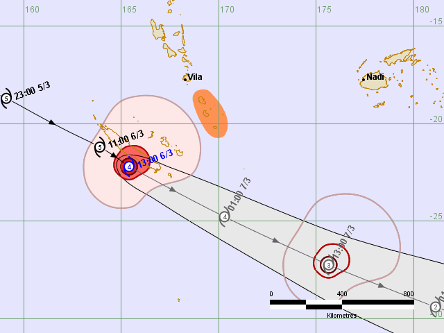
At 3:00 pm local time, Severe Tropical Cyclone NIRAN [927hPa] Category 4, was
located at 22.2 degrees South 165.4 degrees East. This is about 600KM south southwest
of Efate and 500KM southwest of Tanna. The system is positioned at the top center
of square letter F, number 13 (F,13) in the New Vanuatu Tropical Cyclone Tracking
Map, [Top Center of Square letter E, number 12 (E,12) in the Old Vanuatu Tropical
Cyclone Tracking Map]. Severe Tropical Cyclone NIRAN has been moving in an
east southeasterly direction at 81KM/HR (44Knots) in the past 3 hours. Maximum
sustained winds close to the center are estimated at 185KM/HR (100Knots).
Strong to gale force winds of 90KM/HR (47Knots), gusting to 110KM/HR (55Knots) is
expected to affect TAFEA PROVINCE today.
Destructive storm force winds of 120KM/HR (63Knots) with gusting up to 150KM/HR
80Knots) expected within 40 Nautical miles from the center.
Hurricane force winds of 185KM/HR (100Knots), gusting to 185KM/HR (145Knots)
expected within 20 Nautical miles from the center.
The Severe Tropical Cyclone NIRAN is forecast to be at 24.8 degrees South
170.3 degrees East in the next 3 to 6 hours.
Forecast Positions
Date and Time Position Intensity
+06 hours (7pm, 6 Mar) 23.5S, 167.8E 100 KTS (185 KM/HR)
+12 hours (1am, 7 Mar) 24.8S, 170.3E 100 KTS (185 KM/HR)
+18 hours (7am, 7 Mar) 26.0S, 172.9E 100 KTS (185 KM/HR)
+24 hours (1pm, 7 Mar) 27.2S, 175.6E 80 KTS (150 KM/HR)
+36 hours (1am, 8 Mar) 29.4S, 178.9W 60 KTS (110 KM/HR)
+48 hours (1pm, 8 Mar) 30.9S, 174.1W 40 KTS (75 KM/HR)
+60 hours (1am, 9 Mar) 31.5S, 170.5W 40 KTS (75 KM/HR)
+72 hours (1pm, 9 Mar) 31.5S, 168.0W 25 KTS (45 KM/HR)
Rough seas with swells expected throughout the group today and continuing tonight.
High Seas wind warning is current for all open waters of Vanuatu group. Marine strong
wind warning is current for all coastal waters of Vanuatu. Very strong inland winds
of more than 30knots (55KM/HR) will continue to affect Tafea and Shefa province today.
People, including sea going vessels are advised to take extra precautions until the
system has completely moved out of Vanuatu waters. Winds over these areas will slowly
weaken as the system moves further in the east southeasterly direction.
The Vanuatu National Disaster Management Office (NDMO) advises that Red Alert is still
inforce for TAFEA Province while All Clear is now given for SHEFA Province. For actions
on this alert call NDMO on 22699,33366, 7738201 and 7720836
The Vanuatu Meteorology and Geo-Hazards Department will issue the next warning on
Severe Tropical Cyclone NIRAN at 6:00pm. People are advised to listen to Radio
Vanuatu for the latest information on this system.
This warning bulletin is also available on https://www.vmgd.gov.vu, Toll Free No:116 and
https://www.facebook.com/vmgd.gov.vu 
|
|