開啟輔助訪問
 找回密碼
 立即加入

08L.Henri 路徑迂迴 登陸美國羅德島州

簽到天數: 1650 天

[LV.Master]伴壇終老

2021-8-15 08:06 | 顯示全部樓層
  一級颶風  
編號:08 L
名稱:Henri
234057wsii7nwco7oip1mi.jpg
  基本資料  
擾動編號日期:2021 08 15 07
命名日期  :2021 08 17 05
撤編日期  :2021 08 25 02
登陸地點  :美國 羅德島州

  巔峰時期資料  
近中心最強風速 :65  kt ( Cat.1 )
海平面最低氣壓 :991 百帕

  擾動編號資料  
96L.INVEST.15kts.1013mb.37N.65W

20210814.2330.goes-16.ir.96L.INVEST.15kts.1013mb.37N.65W.100pc.jpg
NHC:20%
1. A small area of low pressure associated with disorganized showers
and thunderstorms has developed more than 200 miles north-northeast
of Bermuda. Some gradual development is possible over this weekend
into early next week as this system drifts slowly southward near
Bermuda over the next few days.
* Formation chance through 48 hours...low...20 percent.
* Formation chance through 5 days...low...30 percent.
two_atl_2d1 (27).png
two_atl_5d1 (28).png
以上資料來自:NHC、颱風論壇整理製作

評分

參與人數 1水氣能量 +15 +1 收起 理由
t02436 + 15 + 1

查看全部評分

回復

使用道具 舉報

簽到天數: 3206 天

[LV.Master]伴壇終老

king111807|2021-8-15 14:54 | 顯示全部樓層
NHC展望升至30%
1. A small but well-defined low pressure system located about 200 miles
north-northeast of Bermuda is producing disorganized showers and
thunderstorms mainly to the south and southwest of the center. Some
gradual development is possible over the next couple of days while
the system moves slowly southward near or to the east of Bermuda. By
Tuesday, however, environmental conditions are forecast to become
less conducive for tropical cyclone formation.
* Formation chance through 48 hours...low...30 percent.
* Formation chance through 5 days...low...30 percent.
two_atl_2d1.png
回復

使用道具 舉報

簽到天數: 1650 天

[LV.Master]伴壇終老

老農民版夜神月|2021-8-16 04:11 | 顯示全部樓層
NHC展望提升至Medium,40%
1. A small but well-defined low pressure system located about 175
miles northeast of Bermuda continues to produce disorganized
shower and thunderstorm activity.  Environmental conditions appear
conducive for some development of this low during the next couple
of days, and a tropical depression could form while it moves slowly
to the south or south-southwest at about 5 mph, near or to the east
of Bermuda.  By Tuesday, upper-level winds are forecast to become
less conducive for tropical cyclone formation.  Interests in Bermuda
should monitor the progress of this system during the next few days.
* Formation chance through 48 hours...medium...40 percent.
* Formation chance through 5 days...medium...40 percent.
two_atl_2d1 (28).png two_atl_5d1 (29).png
96L_gefs_latest (1).png
回復

使用道具 舉報

簽到天數: 1650 天

[LV.Master]伴壇終老

老農民版夜神月|2021-8-16 07:36 | 顯示全部樓層
本帖最後由 老農民版夜神月 於 2021-8-16 08:29 編輯

FWC-N發布TCFA al962021.gif 20210815.2200.goes-16.vis.2km.96L.INVEST.25kts.1014mb.34.1N.62.8W.pc.jpg
GOES00102021228JPrUCB.jpg
FM FLEWEACEN NORFOLK VA
TO HURRIWARNLANT
INFO FLEWEACEN NORFOLK VA
FLEWEACEN SAN DIEGO CA
JOINT TYPHOON WRNCEN PEARL HARBOR HI
BT
UNCLAS
SUBJ/TROPICAL CYCLONE FORMATION ALERT (96L)//
WTNT21 KNGU 152300
SUBJ/TROPICAL CYCLONE FORMATION ALERT//
RMKS/1. FORMATION OF A SIGNIFICANT TROPICAL CYCLONE IS POSSIBLE
WITHIN 100 NM EITHER SIDE OF A LINE FROM 34.2N 62.8W TO 31.8N 62.9W
WITHIN THE NEXT 24 HOURS. AVAILABLE DATA DOES NOT JUSTIFY
ISSUANCE OF NUMBERED TROPICAL CYCLONE WARNINGS AT THIS TIME.
WINDS IN THE AREA ARE ESTIMATED TO BE 15 TO 20 KNOTS. METSAT
IMAGERY, SYNOPTIC DATA AND RADAR DATA AT 151200Z INDICATE THAT A
CIRCULATION CENTER IS LOCATED NEAR 34.1N 62.8W. THE SYSTEM IS
MOVING SOUTHWARD AT 06 KNOTS.
2. EARLIER TODAY, SATELLITE WIND DERIVED DATA AND VISIBLE IMAGES
INDICATED THAT AN AREA OF DISTURBED WEATHER, LOCATED ABOUT 160 MILES
NORTHEAST OF BERMUDA, HAD DEVELOPED A SMALL, WELL-DEFINED SUREFACE
CIRCULATION. SHOWERS AND THUNDERSTORMS ASSOCIATED WITH THIS LOW
PRESSURE SYSTEM HAVE BECOME BETTER ORGANIZED THIS EVENING. ALTHOUGH
ENVIRONMENTAL CONDITIONS APPEAR SOMEWHAT CONDUCTIVE FOR FURTHER
DEVELOPMENT, A SHORT-LIVED TROPICAL CYCLONE COULD FORM TONIGHT OR
MONDAY IF CONVECTIVE TRENDS CONTINUE WHILE IT DRIFTS GENERALLY
SOUTHWARD AT ABOUT 4 TO 6 KT.
REFER TO TROPICAL STORM FRED (06L) WARNINGS (WTNT01 KNGU)
FOR SIX-HOURLY UPDATES AND TROPICAL DEPRESSION GRACE (07L) WARNINGS
(WTNT02 KNGU) FOR SIX-HOURLY UPDATES.  
3. THIS ALERT WILL BE REISSUED, UPGRADED TO WARNING OR CANCELLED BY
162300Z.//
BT
NNNN

回復

使用道具 舉報

簽到天數: 1650 天

[LV.Master]伴壇終老

老農民版夜神月|2021-8-16 08:26 | 顯示全部樓層
NHC展望提升至High,90%
1. Satellite imagery and radar data from Bermuda indicate that showers
and thunderstorms associated with a small but well-defined area of
low pressure located northeast of Bermuda have continued to become
better organized during the past few hours. If this trend continues,
advisories will likely be initiated on a new tropical depression
later tonight. The system is forecast to move slowly toward the
south or southwest during the next day or so, and then turn westward
on Tuesday, passing near or just east and south of Bermuda.
Interests in Bermuda should monitor the progress of this system,
and a Tropical Storm Watch could be required for that island
tonight.
* Formation chance through 48 hours...high...90 percent.
* Formation chance through 5 days...high...90 percent.
two_atl_2d1 (29).png two_atl_5d1 (30).png
96L_gefs_latest (2).png
回復

使用道具 舉報

簽到天數: 1650 天

[LV.Master]伴壇終老

老農民版夜神月|2021-8-16 11:04 | 顯示全部樓層
本帖最後由 老農民版夜神月 於 2021-8-16 11:06 編輯

NHC升格TD08L,初報上望55KT 030223_5day_cone_with_line_and_wind.png 20210816.0019.mta.ASCAT.wind.96L.INVEST.30kts-1013mb.335N.628W.25km.noqc.jpeg
643
WTNT43 KNHC 160301
TCDAT3

Tropical Depression Eight Discussion Number   1
NWS National Hurricane Center Miami FL       AL082021
1100 PM AST Sun Aug 15 2021

A small well-defined low pressure system located just
east-northeast of Bermuda has produced persistent deep convection
since this morning. Radar imagery from Bermuda along with
geostationary and polar orbiting microwave satellite data show that
the convection is sufficiently well organized to meet the
definition for a tropical cyclone. Therefore advisories have been
started on Tropical Depression Eight.  The initial intensity is set
at 25 kt, based on believable winds near that value in a pair of
recent ASCAT overpasses. Dvorak estimates from TAFB and SAB were a
little higher, so this estimate could be slightly conservative.

Confidence in the forecast is reasonably high for the next 48 to
72 h. The depression should make a slow clockwise turn around
Bermuda, steered by a mid-level ridge currently centered off the
coast of the Carolinas. Warm SSTs should provide ample fuel to
support at least slight strengthening during this period, despite
expected northerly shear, and this is shown by all of the intensity
guidance. The NHC forecast is very near the multi-model consensus
for both track and intensity through that period.

Beyond 72 h, the track and intensity models diverge quickly. The
HWRF and COAMPS-TC models rapidly intensify the system to major
hurricane strength. A stronger, deeper vortex would likely be
steered generally westward through the end of the forecast period,
influenced by a deeper-layer steering flow.  However, the global
models have a much weaker, shallower system which turns northward,
and then possibly accelerates northeastward by day 5. As a result,
the spread in the track guidance is nearly 800 n mi by day 5, with
the GFS and HWRF taking the extreme positions to the northeast and
southwest, respectively. The official track forecast takes a middle
approach, and is between the various consensus aids at days 4 and
5. The NHC intensity forecast is slightly more conservative, and is
below the consensus at the end of the period. Significant changes
to the forecast may be required in subsequent advisory packages.


FORECAST POSITIONS AND MAX WINDS

INIT  16/0300Z 33.2N  62.7W   25 KT  30 MPH
12H  16/1200Z 32.4N  62.8W   30 KT  35 MPH
24H  17/0000Z 31.5N  63.3W   35 KT  40 MPH
36H  17/1200Z 31.1N  64.0W   40 KT  45 MPH
48H  18/0000Z 31.0N  64.9W   45 KT  50 MPH
60H  18/1200Z 31.0N  66.1W   50 KT  60 MPH
72H  19/0000Z 31.2N  67.4W   55 KT  65 MPH
96H  20/0000Z 32.0N  68.5W   55 KT  65 MPH
120H  21/0000Z 33.5N  68.0W   55 KT  65 MPH

$$
Forecaster Zelinsky
20210816.0240.goes-16.ir.96L.INVEST.30kts.1013mb.33.5N.62.8W.100pc.jpg
回復

使用道具 舉報

簽到天數: 1650 天

[LV.Master]伴壇終老

老農民版夜神月|2021-8-17 05:10 | 顯示全部樓層
NHC升格TS,命名Henri
000
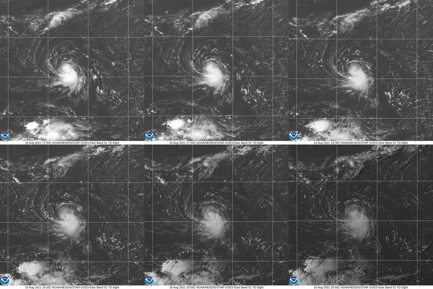
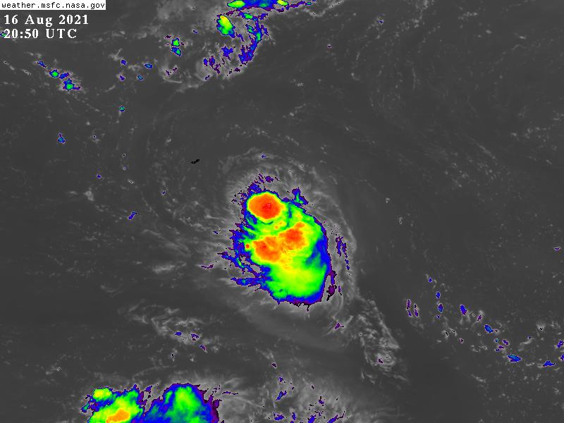
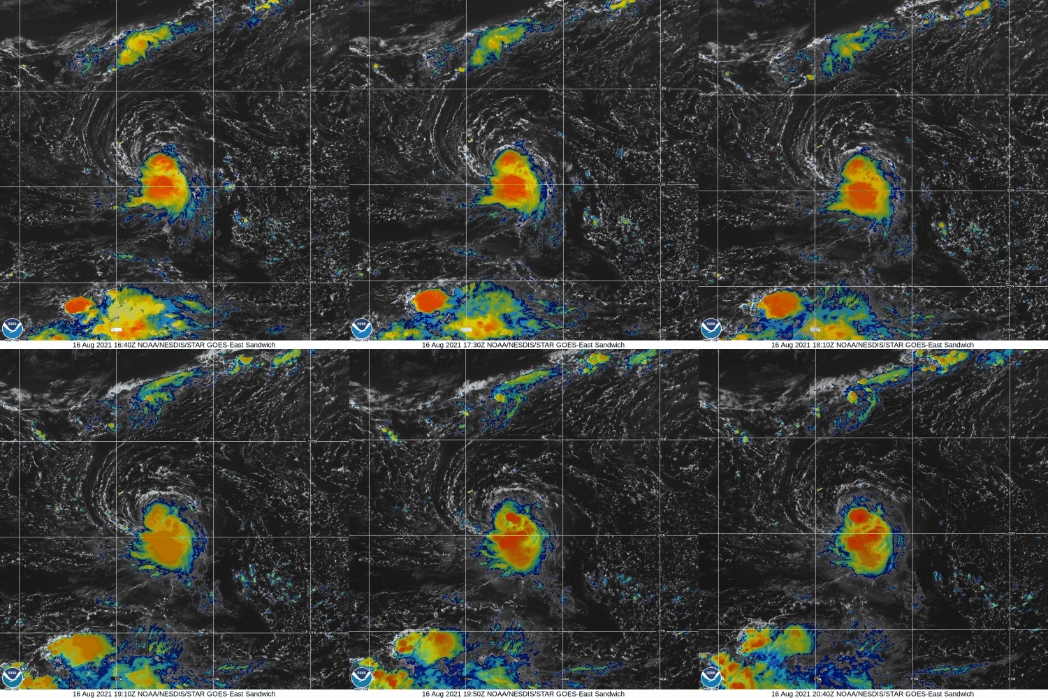
WTNT43 KNHC 162046
TCDAT3

Tropical Storm Henri Discussion Number   4
NWS National Hurricane Center Miami FL       AL082021
500 PM AST Mon Aug 16 2021

Deep convection has persisted near and southeast of the center
of the small tropical cyclone today, and subjective Dvorak
intensity estimates were a consensus T2.5 (35 kt) at 1800 UTC.  
Objective estimates from ADT and SATCON also support tropical
storm status, therefore the depression has been upgraded to a
35-kt tropical storm with this advisory.  Henri (ahn-REE) becomes
the eighth named storm of the 2021 Atlantic hurricane season.  This
is the fourth-earliest eighth storm on record with only 2020,
2005, and 1936 having the eighth-named storm form earlier in the
season.

Henri is located over warm waters, but is currently being affected
by light to moderate northerly shear and dry mid-level air in the
surrounding environment.  Although these conditions are not overly
conducive for strengthening, most of the intensity guidance
supports gradual intensification over the next 24 to 48 hours.  
After that time, a significant increase in northeasterly
upper-level winds is depicted by the global models over the system,
which is likely to halt further strengthening.  In fact, given the
small size of Henri, it is likely to be more susceptible to the
increase in shear, and it could weaken faster than indicated below.
The HWRF remains more aggressive, but given the expected increase in
shear, that solution still does not seem likely.  The NHC intensity
forecast is in best agreement with the LGEM model, and is slightly
below the IVCN intensity consensus.

The tropical storm is moving south-southwestward or 200/6 kt. Henri
is forecast to move west-southwestward during the next 12-24 hours
around the southeastern side of a mid-tropospheric high over the
western Atlantic.  After that time, Henri should turn westward as
the ridge shifts eastward to the north of the tropical cyclone, and
after 72 hours Henri is expected to approach the western extent of
the ridge and should turn northward and then north-northeastward.
The dynamical model guidance is in somewhat better agreement during
the next 48-72 hours, but there remains some spread later in
the period as to how sharp of northward turn occurs.  The new NHC
track forecast is similar to the previous advisory and lies near
the center of the guidance envelope.

FORECAST POSITIONS AND MAX WINDS

INIT  16/2100Z 31.0N  62.9W   35 KT  40 MPH
12H  17/0600Z 30.5N  63.4W   40 KT  45 MPH
24H  17/1800Z 30.3N  64.2W   45 KT  50 MPH
36H  18/0600Z 30.2N  65.4W   50 KT  60 MPH
48H  18/1800Z 30.2N  66.9W   50 KT  60 MPH
60H  19/0600Z 30.3N  68.5W   50 KT  60 MPH
72H  19/1800Z 30.5N  69.9W   45 KT  50 MPH
96H  20/1800Z 31.8N  70.2W   45 KT  50 MPH
120H  21/1800Z 34.2N  68.4W   45 KT  50 MPH

$$
Forecaster Brown
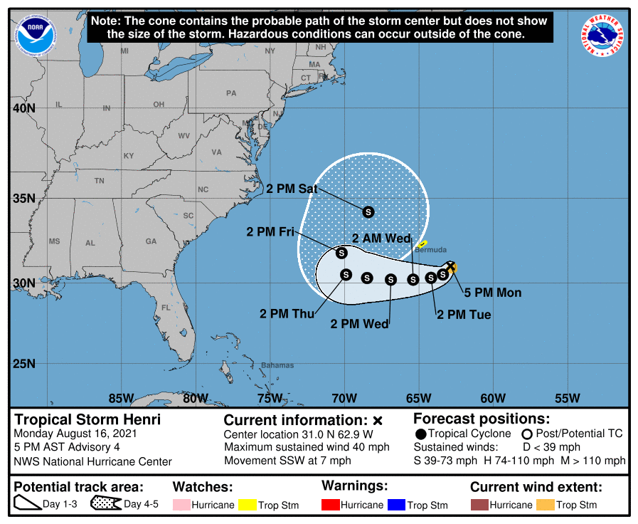
205307_5day_cone_no_line_and_wind.png floater_floater_AL082021_band01_24fr_20210816-1708.gif
GOES20502021228kU4pUx.jpg
floater_floater_AL082021_Sandwich_24fr_20210816-1709.gif
回復

使用道具 舉報

簽到天數: 1650 天

[LV.Master]伴壇終老

老農民版夜神月|2021-8-18 05:39 | 顯示全部樓層
發展超乎預期,NHC上調預測強度 204104_5day_cone_no_line_and_wind.png 20212292100_GOES16-ABI-FL-GEOCOLOR-AL082021-1000x1000.jpg
000
WTNT43 KNHC 172040
TCDAT3

Tropical Storm Henri Discussion Number   8
NWS National Hurricane Center Miami FL       AL082021
500 PM AST Tue Aug 17 2021

Henri appears to be gaining strength.  Satellite images show banding
features becoming increasingly curved, especially on the east side
of the system, and an eye feature has been occasionally seen in
radar images from Bermuda.  The upper-level outflow is also well
established to the north and east of the center.  The center itself
is estimated to be located near the western edge of the convection,
but it is possible that a new center is forming farther east.  The
initial intensity is raised to 55 kt following the Dvorak
classification from TAFB.  The initial wind radii has been expanded
outward based on an earlier ASCAT pass.

The tropical storm appears to have slowed down, and the latest
initial motion estimate is 255/2 kt.  A subtropical ridge over the
western Atlantic is building eastward to the north of Henri, and
this feature should steer the storm westward at a slightly faster
pace during the next two to three days.  After that time, the ridge
is expected to weaken and shift farther east as a cut off low or
negatively-tilted trough develops over the northeast U.S.  This
change in the steering pattern should cause Henri to turn
northeastward between Bermuda and the east coast of the U.S in the
72-120 h period.  There is a fair amount of spread in exactly when
and where Henri makes this turn and the GFS and EC ensembles have
some members not far offshore of New England and Atlantic Canada.
Overall, the guidance has shifted westward again this cycle, and the
NHC track forecast has been adjusted accordingly from days 3 to 5.

The northwesterly shear currently affecting Henri is subsiding,
which should allow the storm to gain a little more strength tonight.
However, a round of moderate northerly shear is expected to setup
over Henri on Wednesday and Thursday and that will likely
temporarily end the opportunity for strengthening.  Although this
shear would typically cause some weakening, the combination of warm
SSTs and increasing mid-level moisture could offset the negative
influences of the shear.  By Friday and over the weekend, the shear
is expected to lessen again and since the other environmental
factors are predicted to remain favorable for the storm,
strengthening is shown from days 3-5.  This forecast is above the
previous one, and lies fairly close to the middle of the guidance
envelope.


FORECAST POSITIONS AND MAX WINDS

INIT  17/2100Z 30.4N  64.2W   55 KT  65 MPH
12H  18/0600Z 30.3N  65.5W   60 KT  70 MPH
24H  18/1800Z 30.2N  67.0W   60 KT  70 MPH
36H  19/0600Z 30.2N  68.6W   60 KT  70 MPH
48H  19/1800Z 30.3N  70.0W   60 KT  70 MPH
60H  20/0600Z 31.0N  71.1W   60 KT  70 MPH
72H  20/1800Z 32.0N  71.5W   65 KT  75 MPH
96H  21/1800Z 35.5N  69.6W   70 KT  80 MPH
120H  22/1800Z 39.1N  65.2W   70 KT  80 MPH

$$
Forecaster Cangialosi
GOES21202021229hcosD5.jpg 20210817.1337.mtb.ASCAT.wind.08L.HENRI.45kts-1004mb.305N.640W.25km.noqc.jpeg
回復

使用道具 舉報

123下一頁
快速回覆
您需要登錄後才可以回帖 登錄 | 立即加入

本版積分規則

本平台僅供學術討論之用,預報應以氣象局為準

威普網站虛擬主機贊助公司

臺灣第一個天氣類型社群平台 即時天氣資訊、精準颱風動態

線上客服
FB傳送訊息
廣告行銷
精準行銷 物超所值
官方粉專
發佈 快速回復 返回頂部 返回列表