開啟輔助訪問
 找回密碼
 立即加入

08L.Henri 路徑迂迴 登陸美國羅德島州

簽到天數: 1650 天

[LV.Master]伴壇終老

老農民版夜神月|2021-8-19 05:41 | 顯示全部樓層
08L_BAND01.gif
根據NHC新報,後期可能將影響美國東北沿岸地區 204927_5day_cone_no_line_and_wind (1).png HENRI.png
08L_gefs_latest.png

FORECAST POSITIONS AND MAX WINDS

INIT  18/2100Z 29.9N  67.6W   60 KT  70 MPH
12H  19/0600Z 29.8N  69.0W   60 KT  70 MPH
24H  19/1800Z 29.8N  70.7W   60 KT  70 MPH
36H  20/0600Z 30.1N  72.3W   65 KT  75 MPH
48H  20/1800Z 31.0N  73.2W   70 KT  80 MPH
60H  21/0600Z 32.7N  72.7W   75 KT  85 MPH
72H  21/1800Z 35.2N  71.7W   80 KT  90 MPH
96H  22/1800Z 39.3N  70.0W   70 KT  80 MPH
120H  23/1800Z 41.4N  69.8W   60 KT  70 MPH

回復

使用道具 舉報

簽到天數: 1650 天

[LV.Master]伴壇終老

老農民版夜神月|2021-8-20 05:56 | 顯示全部樓層
本帖最後由 老農民版夜神月 於 2021-8-20 05:57 編輯

08L_BAND01 (1).gif 20210819.2039.f16.91pct91h91v.08L.HENRI.55kts.999mb.29.6N.71W.085pc.jpg


即將逐漸轉向北上
據目前的預報,08L有些許可能在60H內衝擊C2,甚至MH的強度


204056_5day_cone_no_line_and_wind.png 08L_intensity_latest.png
000
WTNT43 KNHC 192039
TCDAT3

Tropical Storm Henri Discussion Number  16
NWS National Hurricane Center Miami FL       AL082021
500 PM EDT Thu Aug 19 2021

The Air Force Hurricane Hunters investigated Henri earlier this
afternoon and found maximum flight-level winds and SFMR values to
support an intensity of about 55 kt and a minimum pressure of 997
mb.  The storm's appearance in satellite images has been generally
steady throughout the day with the low-level center located on the
northern side of the convective mass, and banding features confined
to the south side of the circulation.  This somewhat asymmetric
cloud pattern is due to about 25 kt of north-northeasterly shear.

The tropical storm is now moving due westward at 9 kt.  A mid-level
ridge should keep Henri on a westward to west-northwestward track
through tonight.  On Friday, however, a trough is expected to cut
off over the Ohio Valley and mid-Atlantic region of the U.S. while a
ridge amplifies to the east of Henri over the western Atlantic.  A
combination of these features should cause Henri to turn northward
on Friday and accelerate in that direction over the weekend.  The
exact location of the northward turn will be very critical in
determining Henri's future track and how close it gets to New
England.  The latest GFS run has shifted eastward and the UKMET and
ECMWF have shifted westward. Consequently, the net result is very
little change in the consensus models and the new NHC track
forecast is just a little faster than the previous one.  Based on
this forecast, Henri is expected to be very near southern New
England on Sunday and Monday. The NOAA Gulfstream IV jet will be
flying around Henri this evening to help assess the environmental
conditions and gather data for the numerical models. It is hoped
that these data will help the models more accurately predict the
future track of the storm.

Although Henri is a bit weaker now, the overall intensity forecast
philosophy has not changed.  The shear is expected to persist for
another 12 to 24 hours, so little change in strength seems likely
during that time period.  However, the global models show a more
conducive upper-level wind pattern over Henri shortly after that,
and in fact, all of the environmental conditions appear favorable
for strengthening on Friday and Saturday.  Therefore, steady
intensification is expected during the 24-60 h time period, and
Henri is forecast to become a hurricane during that time.  Henri is
expected to cross the north wall of the Gulf Stream and move over
much cooler SSTs on Sunday, and that should end the opportunity for
strengthening and induce a steady weakening trend from days 3 to 5.
Post-tropical transition is now shown to occur by the end of the
forecast period when Henri is expected to be over SSTs below 20
deg C.

It should be noted that as Henri gains latitude and moves near
New England, the wind field is expected to expand.  Therefore,
users are reminded to not focus on the exact forecast points as
impacts will extend far from the center.

Key Messages:

1. Henri is forecast to be near the northeast coast of the U.S.
on Sunday and Monday, and the risks of storm surge, wind, and rain
impacts in portions of southern New England and eastern Long Island
are increasing.  Watches will likely be required for portions of
this area early Friday.

2. Swells from Henri will begin to reach much of the east coast of
the U.S. and Atlantic Canada by the end of the week and continue
through the weekend. These swells could cause life-threatening surf
and rip currents.

3. Heavy rainfall may lead to flash, urban, and small stream
flooding over portions of southeastern New England Sunday into
Monday.


FORECAST POSITIONS AND MAX WINDS

INIT  19/2100Z 29.7N  71.4W   55 KT  65 MPH
12H  20/0600Z 30.1N  72.6W   55 KT  65 MPH
24H  20/1800Z 31.0N  73.2W   55 KT  65 MPH
36H  21/0600Z 33.0N  72.6W   65 KT  75 MPH
48H  21/1800Z 36.0N  71.3W   75 KT  85 MPH
60H  22/0600Z 38.9N  70.3W   80 KT  90 MPH
72H  22/1800Z 40.8N  70.1W   65 KT  75 MPH
96H  23/1800Z 42.3N  69.6W   50 KT  60 MPH
120H  24/1800Z 43.6N  65.7W   40 KT  45 MPH...POST-TROPICAL

$$
Forecaster Cangialosi
回復

使用道具 舉報

簽到天數: 3279 天

[LV.Master]伴壇終老

t02436|2021-8-20 23:52 | 顯示全部樓層
開始轉向北上,預測+60將以TS上限強度登陸康乃狄克州,直接侵襲波士頓等東北部城市
152236_5day_cone_with_line.png
455
WTNT43 KNHC 201445
TCDAT3

Tropical Storm Henri Discussion Number  19
NWS National Hurricane Center Miami FL       AL082021
1100 AM EDT Fri Aug 20 2021

The Air Force Reserve Hurricane Hunters investigated Henri this
morning and based on the flight-level, SFMR, and dropsonde data, the
initial intensity is still around 55 kt.  The minimum pressure has
also been relatively steady.  The low-level center of Henri is
located close to the northwestern edge of the main area of deep
convection, and the vortex is still not vertically aligned due to
20-25 kt of northerly vertical wind shear.  Although the intensity
of Henri has not changed much during the past couple of days,
satellite images show an improving cloud pattern with well-
established outflow in the eastern semicircle, which could indicate
that Henri is poised to strengthen.

There is some uncertainty in the exact position of Henri given the
recent aircraft fixes and the tilt of the vortex, but the initial
motion appears to be northwestward at 6 kt.  A trough over the
central Appalachians is expected to cut off tonight, and the
combination of that feature and a building ridge to the
east/northeast of Henri should cause the storm to turn northward
tonight and accelerate in that direction on Saturday. Some of the
models show a slight bend to the west around the time Henri is
forecast to make landfall on Sunday, and there remains a fair amount
spread in the guidance in where the center of Henri will come
ashore.  The latest GFS and ECMWF ensemble members span a region
from near New York City to Cape Cod for the landfall point.  Based
on the latest consensus aids and initial position, the official
track forecast is nudged to the west of the previous one and shows
landfall occurring by late Sunday.  After day 3, Henri is forecast
to eject northeastward across the Gulf of Maine.

The ongoing northerly shear is expected to decrease later today, and
the global models show a favorable upper-level wind pattern
developing over the storm later today through the weekend.  These
more conducive atmospheric conditions combined with the warm Gulf
Stream waters should allow Henri to strengthen to a hurricane
tonight or early Saturday with additional intensification expected
into Saturday night.  By early Sunday, however, Henri is forecast to
cross the north wall of the Gulf Stream, and that should end its
opportunity for strengthening. Although steady to rapid weakening is
forecast while Henri moves over cooler waters south of New England,
it will likely still be at or very near hurricane intensity when it
reaches the coast. Post-tropical transition is forecast to occur in
3 to 4 days, and the new forecast shows Henri dissipated by day 5,
in agreement with most of the global models.

Users are reminded to not focus on the exact forecast of the
center of Henri since impacts will extend far from the center.

Key Messages:

1. Dangerous storm surge inundation and hurricane conditions are
possible beginning Sunday in portions of Long Island, Connecticut,
Rhode Island, and southeastern Massachusetts, where a Storm Surge
Watch and Hurricane Watch are in effect. Residents in these areas
should follow any advice given by local officials.

2. Heavy rainfall may lead to flash, urban, and small stream
flooding, along with the potential for widespread minor and isolated
moderate river flooding, over portions of southern New England
Sunday into Monday.

3. Swells from Henri will begin to reach much of the east coast of
the U.S. and Atlantic Canada by the end of the week and continue
through the weekend. These swells could cause life-threatening surf
and rip currents.

FORECAST POSITIONS AND MAX WINDS

INIT  20/1500Z 30.4N  73.7W   55 KT  65 MPH
12H  21/0000Z 31.5N  73.7W   60 KT  70 MPH
24H  21/1200Z 34.1N  72.7W   70 KT  80 MPH
36H  22/0000Z 37.3N  71.8W   75 KT  85 MPH
48H  22/1200Z 39.8N  71.7W   65 KT  75 MPH
60H  23/0000Z 41.4N  71.8W   60 KT  70 MPH...INLAND
72H  23/1200Z 42.4N  71.8W   40 KT  45 MPH...INLAND
96H  24/1200Z 43.7N  69.4W   35 KT  40 MPH...POST-TROPICAL
120H  25/1200Z...DISSIPATED

$$
Forecaster Cangialosi


08L_RBTOP.gif
回復

使用道具 舉報

簽到天數: 1650 天

[LV.Master]伴壇終老

老農民版夜神月|2021-8-21 05:44 | 顯示全部樓層
goes16_rainbow_08L.gif
NHC新報定強來到TS上限60節,可能即將升格C1
並預測+24H後便將達到顛峰70節
599
WTNT43 KNHC 202042
TCDAT3

Tropical Storm Henri Discussion Number  20
NWS National Hurricane Center Miami FL       AL082021
500 PM EDT Fri Aug 20 2021

Henri appears to be slowly gaining strength.  Deep convection has
been increasing during the past few hours and the upper-level
outflow continues to become better established on the east side of
the circulation.  However, the low-level center is still located
near the northwestern edge of the deep convection due to ongoing
northerly wind shear.  An ASCAT-B pass from a few hours ago showed
peak winds of around 55 kt, with the strongest winds on the
southeast side of the circulation. Based on this data, the initial
intensity is set at 60 kt.  An Air Force Reserve Hurricane Hunter
aircraft is scheduled to investigate Henri again this evening and
the data the plane collects will be very helpful in estimating the
storm's strength and structure.

The tropical storm appears to be making the advertised turn to the
right, with the latest initial motion estimated to be 335/6 kt.  A
trough over the central Appalachians is expected to cut off tonight,
and the combination of that feature and a building ridge to the
east/northeast of Henri should cause the storm to accelerate to the
north on Saturday.  The latest model runs have generally trended to
the left again and are a bit faster, with most showing landfall in
about 48 hours.  Most of the models now show a slight left turn
before landfall as Henri gets caught in the circulation of the
aforementioned trough.  The latest GFS and ECMWF ensemble members
continue to span a region from near New York City to Cape Cod for
the landfall point.  Based on the latest consensus aids, the
official track forecast has again been nudged to the west of the
previous one and shows landfall occurring on Sunday.  After day 3,
Henri is forecast to eject northeastward.

The ongoing northerly shear is expected to decrease tonight, and
the global models show a favorable upper-level wind pattern
developing over the storm through the weekend.  These more
conducive atmospheric conditions combined with the warm Gulf
Stream waters should allow Henri to strengthen to a hurricane
tonight or early Saturday, with additional intensification expected
into Saturday night.  By early Sunday, however, Henri is forecast to
cross the north wall of the Gulf Stream, and that should end its
opportunity for strengthening. Although steady to rapid weakening is
forecast while Henri moves over cooler waters south of Long
Island and New England, it will likely still be at or very near
hurricane intensity when it reaches the coast. Post-tropical
transition is forecast to occur by day 3 and the system should
dissipate in 4 or 5 days.

Users are reminded to not focus on the exact forecast of the
center of Henri since impacts will extend far from the center.

Key Messages:

1. Dangerous storm surge inundation is expected to begin Sunday in
portions of Long Island, Connecticut, Rhode Island, and
southeastern Massachusetts, where a Storm Surge Warning has been
issued. Dangerous storm surge is possible beginning Sunday in
western portions of Long Island and Connecticut in the Storm Surge
Watch area.  Residents in these areas should follow any advice given
by local officials.

2. Hurricane conditions are expected to begin Sunday in portions
of Long Island and Connecticut, where a Hurricane Warning has been
issued.  Hurricane conditions are possible Sunday across portions
of Rhode Island and southeastern Massachusetts.

3. Heavy rainfall may lead to considerable flash, urban, and small
stream flooding, along with the potential for widespread minor and
isolated moderate river flooding, over portions of Long Island and
New England Sunday into Monday.

4. Swells from Henri will continue to affect much of the east coast
of the U.S. through the weekend. These swells could cause
life-threatening surf and rip currents.

FORECAST POSITIONS AND MAX WINDS

INIT  20/2100Z 31.2N  73.9W   60 KT  70 MPH
12H  21/0600Z 32.8N  73.3W   65 KT  75 MPH
24H  21/1800Z 35.8N  72.3W   75 KT  85 MPH
36H  22/0600Z 38.9N  71.9W   75 KT  85 MPH
48H  22/1800Z 40.8N  72.4W   65 KT  75 MPH
60H  23/0600Z 42.0N  72.8W   45 KT  50 MPH...INLAND
72H  23/1800Z 42.9N  72.6W   30 KT  35 MPH...POST-TROPICAL
96H  24/1800Z 43.8N  68.9W   25 KT  30 MPH...POST-TROPICAL
120H  25/1800Z...DISSIPATED

$$
Forecaster Cangialosi
152236_5day_cone_no_line_and_wind.png 20212322030_GOES16-ABI-FL-GEOCOLOR-AL082021-1000x1000.jpg LATEST (41).jpg 20210820.1645.gpm.89pct89h89v.08L.HENRI.55kts.996mb.30.1N.73.6W.065pc.jpg
回復

使用道具 舉報

簽到天數: 1650 天

[LV.Master]伴壇終老

老農民版夜神月|2021-8-22 00:05 | 顯示全部樓層
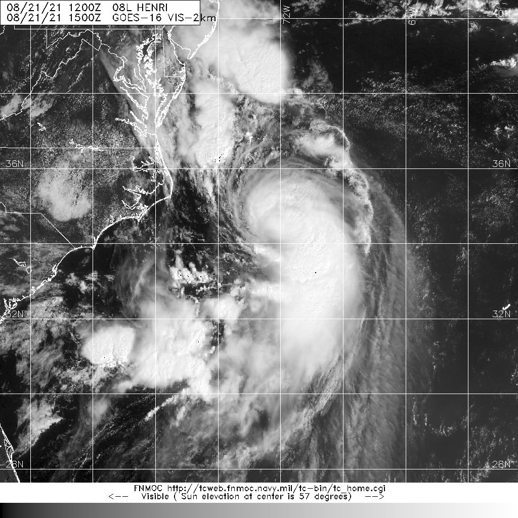
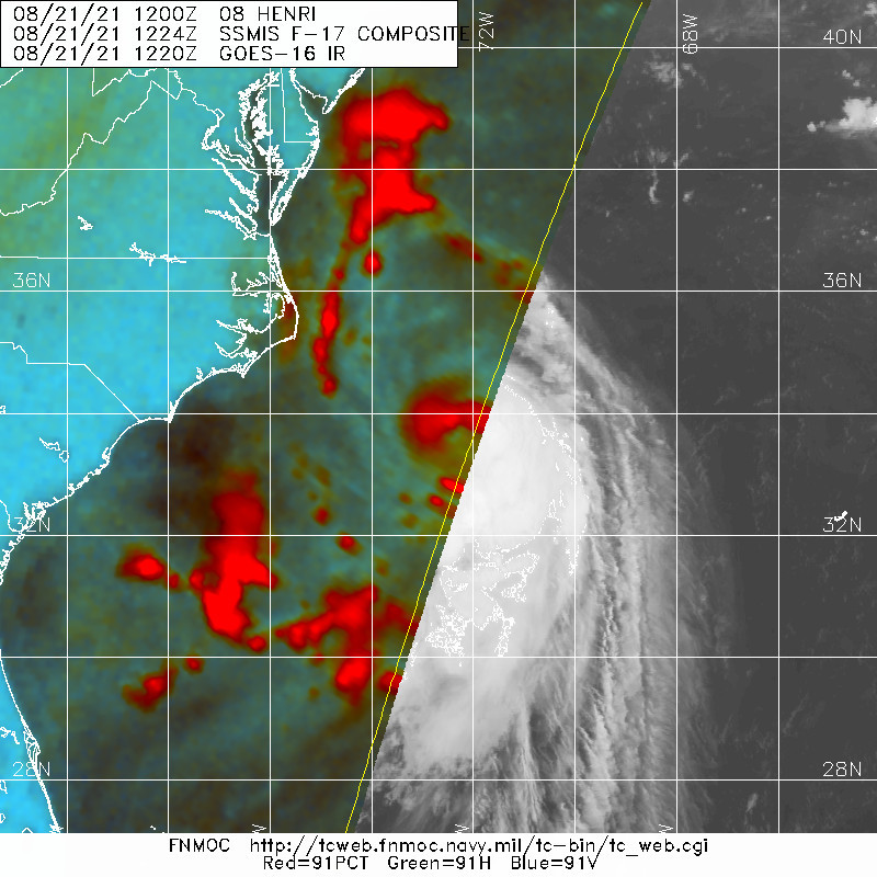
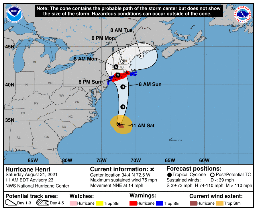
NHC升格C1
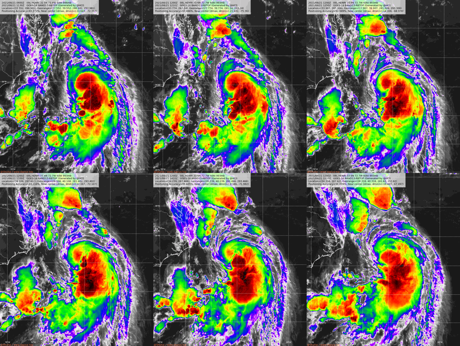
08L_RBTOP.gif 20210821.1500.goes-16.vis.2km.08L.HENRI.60kts.993mb.33.6N.72.7W.pc.jpg
20210821.1224.f17.91pct91h91v.08L.HENRI.60kts.993mb.33.6N.72.7W.055pc.jpg 151351_5day_cone_no_line_and_wind.png
263
WTNT43 KNHC 211442
TCDAT3

Hurricane Henri Discussion Number  23
NWS National Hurricane Center Miami FL       AL082021
1100 AM EDT Sat Aug 21 2021

The Air Force Reserve and NOAA Hurricane Hunters have been
investigating Henri this morning and continue to provide very
valuable data.  The Air Force aircraft measured a peak flight-level
wind of 82 kt at 700 mb, which easily supports hurricane strength,
but the initial intensity is set at 65 kt as a blend of these data
and somewhat lower SFMR winds.  In addition, aircraft data indicate
that the minimum pressure has fallen to 991 mb.  The NOAA tail
Doppler radar data indicate that the storm is becoming more
vertically aligned and that a more symmetric eyewall appears to be
forming.  In addition, dropsonde data from the NOAA Gulfstream IV
aircraft flying around Henri indicate that the 34- and 50-kt wind
radii are a little larger than previously estimated in the
southeastern quadrant.  NOAA buoy 41001 located in the northeastern
quadrant of the hurricane has recently reported 18 ft. seas.

Henri is moving north-northeastward, or 020 degrees, at 12 kt.  The
steering pattern appears fairly well established now with a cut off
low located over the central Appalachians and a ridge building to
the east and northeast of Henri.  This pattern should cause the
storm to accelerate to the north or north-northeast today followed
by a slight bend to the left on Sunday.  The latest run of the GFS
has shifted to the east, but overall the models are focused in on
landfall being between central Long Island and Rhode Island on
Sunday.  However, users are reminded to not focus on the center
itself, as impacts will extend well away from the center, especially
to the east.  The new NHC track forecast is a little to the east of
the previous one and very near the best-performing models, the
consensus aids.

The environment looks favorable for Henri to continue to gain
strength through tonight with low shear, upper-level divergence
associated with the upper-level trough, and warm SSTs.  In fact,
the GFS and HWRF models show the minimum pressure dropping by 15 mb
or more during that time period.  By early Sunday, Henri is
predicted to cross the north wall of the Gulf Stream and that should
cause some weakening, but Henri is forecast to be at or near
hurricane strength at landfall. Once the center moves inland over
the northeast United States, rapid weakening is expected.  Henri is
forecast to become post-tropical in 48-60 hours and dissipate in 3
to 4 days.

Key Messages:

1. Dangerous storm surge inundation is expected to begin late
tonight or Sunday in portions of Long Island, Connecticut,
Rhode Island, and southeastern Massachusetts, where a Storm Surge
Warning has been issued. Dangerous storm surge is possible
beginning late tonight or Sunday in western portions of Long
Island and Connecticut in the Storm Surge Watch area.  Residents in
these areas should follow any advice given by local officials.

2. Hurricane conditions are expected to begin late tonight or
Sunday in portions of Long Island, Connecticut, and Rhode Island,
where a Hurricane Warning is in effect. Tropical storm conditions
will begin in these areas tonight.

3. Heavy rainfall may lead to considerable flash, urban, and small
stream flooding, along with the potential for widespread minor and
isolated moderate river flooding, over portions of Long Island, New
England, southeast New York and northern New Jersey.

4. Swells from Henri will continue to affect much of the east coast
of the U.S. during the next day or two. These swells could cause
life-threatening surf and rip currents.

FORECAST POSITIONS AND MAX WINDS

INIT  21/1500Z 34.4N  72.5W   65 KT  75 MPH
12H  22/0000Z 36.9N  71.9W   75 KT  85 MPH
24H  22/1200Z 39.7N  71.9W   70 KT  80 MPH
36H  23/0000Z 41.3N  72.6W   60 KT  70 MPH...INLAND
48H  23/1200Z 42.4N  72.9W   35 KT  40 MPH...INLAND
60H  24/0000Z 43.1N  71.9W   25 KT  30 MPH...POST-TROP/INLAND
72H  24/1200Z 43.8N  69.2W   25 KT  30 MPH...POST-TROP/INLAND
96H  25/1200Z...DISSIPATED

$$
Forecaster Cangialosi
回復

使用道具 舉報

簽到天數: 3279 天

[LV.Master]伴壇終老

t02436|2021-8-23 00:31 | 顯示全部樓層
15Z評價50節,強對流皆已上陸。
根據最新實測資料,中心已在近岸,一小時內就會正式登陸,登陸點在羅德島州(RI)與康乃狄克州(CT)交界。
151538_5day_cone_with_line.png
000
WTNT43 KNHC 221501
TCDAT3

Tropical Storm Henri Discussion Number  27
NWS National Hurricane Center Miami FL       AL082021
1100 AM EDT Sun Aug 22 2021

Henri's presentation in both satellite and radar imagery has
degraded significantly since the previous advisory due to the
cyclone having moved over much cooler water. An eyewall feature is
no longer evident and clouds tops have warmed markedly in the
inner-core region around the center. Data from an Air Force Reserve
reconnaissance aircraft, NOAA Doppler weather radars, and surface
observations indicate that Henri's peak winds have decreased to
50 kt despite the central pressure remaining constant at about 987
mb.

Henri is moving north-northwestward or 335/10 kt. The cyclone is
forecast to gradually turn northwestward later this afternoon and
possibly even move westward before stalling near the New
York-Connecticut border later tonight owing to interaction with a
mid- to upper-level low located over he DelMarVa region. The latter
system is expected to be absorbed by Henri by early Monday morning
before ejecting out slowly eastward to east-northeastward across
southern New England by Monday afternoon and evening. Henri is then
forecast to cross the southern Gulf of Maine and Nova Scotia as a
remnant low on Tuesday. The new NHC track forecast is a little to
the west and south of the previous advisory track, and lies close
to the tightly packed simple- and corrected-consensus track models.

Little change in strength is expected until Henri makes landfall in
the Rhode Island-eastern Connecticut area this afternoon. After
landfall, rapid weakening is forecast due to land interaction and
entrainment of cooler air coming in off of the Atlantic Ocean. Henri
should weaken to a tropical depression by early Monday, and become
post-tropical by Monday afternoon or evening.

Due to the degraded radar presentation of Henri, hourly Tropical
Cyclone Updates (TCU) will be discontinued after the 1100 AM EDT
advisory.

Key Messages:

1. Dangerous storm surge inundation is expected to continue today
in portions of Long Island, Connecticut, Rhode Island, and
southeastern Massachusetts, where a Storm Surge Warning has been
issued. Residents in these areas should follow any advice given by
local officials.

2. Tropical storm conditions will continue in portions of the
tropical storm warning area into tonight.

3. Heavy rainfall may lead to considerable flash, urban, and small
stream flooding, along with the potential for widespread minor to
isolated moderate river flooding over portions of Long Island, New
England, eastern New York, New Jersey and northeast Pennsylvania.

4. Swells from Henri will continue to affect much of the east coast
of the U.S. during the next day or so. These swells could cause
life-threatening surf and rip currents.

FORECAST POSITIONS AND MAX WINDS

INIT  22/1500Z 41.1N  71.6W   50 KT  60 MPH
12H  23/0000Z 42.4N  73.2W   35 KT  40 MPH...INLAND
24H  23/1200Z 43.0N  72.7W   30 KT  35 MPH...INLAND
36H  24/0000Z 43.3N  71.3W   25 KT  30 MPH...POST-TROP/INLAND
48H  24/1200Z 43.7N  68.7W   25 KT  30 MPH...POST-TROP/INLAND
60H  25/0000Z 44.3N  64.5W   25 KT  30 MPH...POST-TROPICAL
72H  25/1200Z...DISSIPATED

$$
Forecaster Stewart

08L_BAND01.gif
HENRI_AF302_1408A_full.png
HENRI_AF302_1408A_wind_full.png
GOES16102021234viACSK.jpg

中心已於1615Z登陸羅州,登陸強度為50Kts、989hPa。
000
WTNT63 KNHC 221628
TCUAT3

Tropical Storm Henri Tropical Cyclone Update
NWS National Hurricane Center Miami FL       AL082021
1230 PM EDT Sun Aug 22 2021

...TROPICAL STORM HENRI MAKES LANDFALL ALONG THE COAST OF RHODE
ISLAND NEAR WESTERLY...


Data from an Air Force Reserve reconnaissance aircraft, NOAA Doppler
weather radars, and surface observations indicate that the center of
Tropical Storm Henri made landfall along the coast of Rhode Island
near Westerly at approximately 1215 PM EDT this afternoon. At the
time of landfall, maximum sustained winds were estimated to be 60
mph.

A Weatherflow station near Point Judith, Rhode Island, recently
measured a sustained wind of 57 mph (92 km/h) and a gust to 70 mph
(113 km/h). The center of Henri passed over Block Island, Rhode
Island, around 1100 AM EDT...1500 UTC.


SUMMARY OF 1215 PM EDT...1615 UTC...INFORMATION
-----------------------------------------------
LOCATION...41.3N 71.8W
ABOUT 15 MI...25 KM NNE OF MONTAUK POINT NEW YORK
ABOUT 40 MI...65 KM SSW OF PROVIDENCE RHODE ISLAND
MAXIMUM SUSTAINED WINDS...60 MPH...95 KM/H
PRESENT MOVEMENT...NNW OR 335 DEGREES AT 12 MPH...19 KM/H
MINIMUM CENTRAL PRESSURE...989 MB...29.20 INCHES

$$
Forecaster Stewart/Brennan

回復

使用道具 舉報

簽到天數: 1650 天

[LV.Master]伴壇終老

老農民版夜神月|2021-8-23 00:39 | 顯示全部樓層
本帖最後由 老農民版夜神月 於 2021-8-23 00:46 編輯

登陸時部分雲圖,底層掃描,風場掃描

08L_BAND01 (2).gif
goes16_rainbow_08L (1).gif 08L_CA.gif
LATEST (43).jpg
20210822.1208.f17.91pct91h91v.08L.HENRI.55kts.986mb.40.7N.71.3W.085pc.jpg

回復

使用道具 舉報

簽到天數: 1650 天

[LV.Master]伴壇終老

老農民版夜神月|2021-8-23 09:06 | 顯示全部樓層
NHC降格TD
08L HENRI 210823 0000 41.8N 72.9W ATL 30 1000
822
WTNT33 KNHC 222346
TCPAT3

BULLETIN
Tropical Depression Henri Intermediate Advisory Number 28A
NWS National Hurricane Center Miami FL       AL082021
800 PM EDT Sun Aug 22 2021

...HENRI WEAKENING BUT STILL EXPECTED TO PRODUCE HEAVY
RAINFALL AND FLOODING ACROSS PORTIONS OF SOUTHERN NEW ENGLAND AND
THE NORTHERN MID-ATLANTIC STATES THROUGH MONDAY...


SUMMARY OF 800 PM EDT...0000 UTC...INFORMATION
----------------------------------------------
LOCATION...41.7N 72.8W
ABOUT 10 MI...15 KM SW OF HARTFORD CONNECTICUT
ABOUT 90 MI...140 KM NE OF NEW YORK CITY
MAXIMUM SUSTAINED WINDS...35 MPH...55 KM/H
PRESENT MOVEMENT...WNW OR 290 DEGREES AT 7 MPH...11 KM/H
MINIMUM CENTRAL PRESSURE...1000 MB...29.53 INCHES

234648_5day_cone_no_line_and_wind.png
08L_BAND01 (3).gif 08L_RBTOP (1).gif

回復

使用道具 舉報

快速回覆
您需要登錄後才可以回帖 登錄 | 立即加入

本版積分規則

本平台僅供學術討論之用,預報應以氣象局為準

威普網站虛擬主機贊助公司

臺灣第一個天氣類型社群平台 即時天氣資訊、精準颱風動態

線上客服
FB傳送訊息
廣告行銷
精準行銷 物超所值
官方粉專
發佈 快速回復 返回頂部 返回列表